See this text in ![]() or
or ![]()
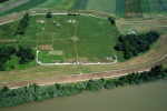
The Roman fort lies directly on the right bank of the Danube within the cadastre
of today’s municipality of Iža (Komárno district), about 4 km east of the mouth
of the Váh River. As an advanced bridgehead of the legionary camp Brigetio
it pertained to the fortification system built up along the north frontier
of the province Pannonia. Today, its area emerges only slightly in the surrounding
flat landscape as a low quadratic height called Leányvár (Dievčí hrad, Devín
= Virgins Castle).
 During
the Marcomannic Wars the territory around the mouth of the Váh River gained
an important strategic meaning. Brigetio was probably one of the base camps
during the Roman military campaigns against the Quadi. At that time the first
fortress was built by the Romans in its forefield on the opposite bank of the
Danube – an earth-and-timber camp. Its size is not completely known yet, but
it must have covered an area of more than 3 hectares. The camp’s fortification
consisted of two deep V-shaped ditches and presumably of earthen ramparts with
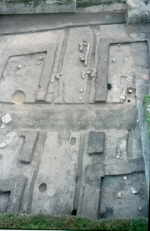
wooden stockade. From among inner constructions so far the remnants of eleven
military barracks were uncovered, arranged street-like at regular distances
next to each other. They were built of adobes and had gabled roofs
covered with reed or cane. These large buildings (up to 44-48 m in length and
11-12 m in width) with thick walls were divided by several partitions into
two sections with three rooms each. Particular rooms still used to be divided
into smaller chambers with wattle-and-daub walls in fixed into the basic frame made of wooden
timbers. Their floor consisted mostly of a thin layer of packed clay, just
in several rooms also an adobe paving could have been detected. Postholes in
floors, fireplaces and remnants of heating stoves are the only evidences of
their sparse inner equipment. The entrances to individual rooms are indicated
by gaps in walls up to 90-100 cm wide. Along the outer walls there were gutters
excavated draining rainwater from roofs that mouthed into some larger collector
channels.
During
the Marcomannic Wars the territory around the mouth of the Váh River gained
an important strategic meaning. Brigetio was probably one of the base camps
during the Roman military campaigns against the Quadi. At that time the first
fortress was built by the Romans in its forefield on the opposite bank of the
Danube – an earth-and-timber camp. Its size is not completely known yet, but
it must have covered an area of more than 3 hectares. The camp’s fortification
consisted of two deep V-shaped ditches and presumably of earthen ramparts with
wooden stockade. From among inner constructions so far the remnants of eleven
military barracks were uncovered, arranged street-like at regular distances
next to each other. They were built of adobes and had gabled roofs
covered with reed or cane. These large buildings (up to 44-48 m in length and
11-12 m in width) with thick walls were divided by several partitions into
two sections with three rooms each. Particular rooms still used to be divided
into smaller chambers with wattle-and-daub walls in fixed into the basic frame made of wooden
timbers. Their floor consisted mostly of a thin layer of packed clay, just
in several rooms also an adobe paving could have been detected. Postholes in
floors, fireplaces and remnants of heating stoves are the only evidences of
their sparse inner equipment. The entrances to individual rooms are indicated
by gaps in walls up to 90-100 cm wide. Along the outer walls there were gutters
excavated draining rainwater from roofs that mouthed into some larger collector
channels.
In the remains of uncovered buildings and around them some distinct traces of fire could be detected. On the floors of the rooms, in drains, on paving and on the level of adjacent streets there were broken and complete ceramic vessels, weapons, parts of military equipment and many iron hobnails from leathern military sandals which maintained the original sole shape. Therefore we are entitled to assume that the reason of this catastrophe most probably was an unexpected attack of the Germans.
 The
most important clues for dating this camp as well as determination of time
of its decline offer the coin finds. It is mostly the coins of Marcus Aurelius
from the period of the Marcomannic Wars whereby the latest of them had been
minted from December 178 until the spring of 179. The destruction of the earth-and-timber
camp at Iža can be thus dated quite exactly to 179. This date is noteworthy
in several respects. According to historical sources, the first invasion of
the Marcomanni and Quadi into the Roman territory is dated to 170.
The
most important clues for dating this camp as well as determination of time
of its decline offer the coin finds. It is mostly the coins of Marcus Aurelius
from the period of the Marcomannic Wars whereby the latest of them had been
minted from December 178 until the spring of 179. The destruction of the earth-and-timber
camp at Iža can be thus dated quite exactly to 179. This date is noteworthy
in several respects. According to historical sources, the first invasion of
the Marcomanni and Quadi into the Roman territory is dated to 170. 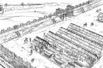 At that time also many north-pannonian Limes camps were destroyed, and also the
legionary camp at Brigetio got considerably damaged. The Roman counteroffensive
began 172 but the fights lasted as late as 175 when the emperor concluded peace
with the Marcomanni and Quadi. The Germans had to displace the zone along the
bank of the Danubian and leave it under the Roman control. However, in 177
some new fights broke out on the north frontier, and one year later Marcus
Aurelius together with his son Commodus had to leave Rome again and set out
for another military campaign. In 179 then the Romans undertook the main counteroffensive.
On the territory of the Marcomanni and Quadi they finally stationed many military
troops with total power of 40 000 men that also have stayed here over winter.
At that time also many north-pannonian Limes camps were destroyed, and also the
legionary camp at Brigetio got considerably damaged. The Roman counteroffensive
began 172 but the fights lasted as late as 175 when the emperor concluded peace
with the Marcomanni and Quadi. The Germans had to displace the zone along the
bank of the Danubian and leave it under the Roman control. However, in 177
some new fights broke out on the north frontier, and one year later Marcus
Aurelius together with his son Commodus had to leave Rome again and set out
for another military campaign. In 179 then the Romans undertook the main counteroffensive.
On the territory of the Marcomanni and Quadi they finally stationed many military
troops with total power of 40 000 men that also have stayed here over winter.
The earth-and-timber camp at Iža was thus destroyed during the second phase
of the Marcomannic wars. A reliable dating of its downfall to 179 reveals
that the position of the Romans at that time was still very precarious as
the Germans dared to plunder their fort in immediate forefield of Brigetio.
It is also obvious that this camp couldn’t have been founded until the outbreak
of the Marcomannic Wars. It could have hardly resisted the first attack by
which even the proper legionary camp at Brigetio got damaged. Therefore it
is very likely that it was not built until the peace was concluded in 175.
It was not constructed as a temporary base camp for military campaigns to
the Quadic territory but as a permanent frontier castle. Its garrison probably
had to monitor the observance of peace conditions, above all to control the
Quadic movement in wider forefield of Brigetio and therewith to defend the
adjacent part of the Limes against their raids. Considering finds of weapons,
e. g. long equestrian swords but above
all number of arrowheads and bone bow plates, it can be assumed that the
substantial part of the garrison was formed by troops of cavalry archers.
Neither in preserved written sources nor at discovered inscriptions there
is any mention about this camp or its garrison.
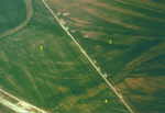
 During an aerial prospecting in 1990 five temporary Roman field camps were discovered
at the fields west of Leányvár. Traces of their ditches were clearly visible
in a large corn field as pale lines forming rectangular structures with characteristic
rounded corners. Each camp was protected by a single ditch and the camps were
situated very close to each other. They were of various measurements, from
130 to330 m long and from 90 to 200 m wide. Extents of these camps varied between
1 and 6,5 hectares. Short interruptions on all four sides of the camp ditches
indicate the positions of entrances. Only two 2-2,5 m wide and almost 2 m deep
V-shaped ditches were excavated that had been constructed very thoroughly and
accurately, as if made upon a pattern. In the filling of one of these ditches
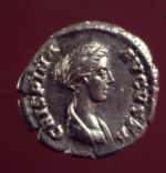
a denar of the emperor Commodus was found, minted for his wife Crispina in
178-183. According to the arrangement and ground plans of these camps they
all can presumably be dated to the same period. The coin found offers an important clue for dating them to the period of the Marcomannic Wars. It is very
likely that after the earth-and-timber camp was plundered, shortly before the
long-time war conflict finished, several military troops had been temporarily
stationed in these field forts before proceeding further onto the Quadic territory
or after returning from such a campaign.
During an aerial prospecting in 1990 five temporary Roman field camps were discovered
at the fields west of Leányvár. Traces of their ditches were clearly visible
in a large corn field as pale lines forming rectangular structures with characteristic
rounded corners. Each camp was protected by a single ditch and the camps were
situated very close to each other. They were of various measurements, from
130 to330 m long and from 90 to 200 m wide. Extents of these camps varied between
1 and 6,5 hectares. Short interruptions on all four sides of the camp ditches
indicate the positions of entrances. Only two 2-2,5 m wide and almost 2 m deep
V-shaped ditches were excavated that had been constructed very thoroughly and
accurately, as if made upon a pattern. In the filling of one of these ditches
a denar of the emperor Commodus was found, minted for his wife Crispina in
178-183. According to the arrangement and ground plans of these camps they
all can presumably be dated to the same period. The coin found offers an important clue for dating them to the period of the Marcomannic Wars. It is very
likely that after the earth-and-timber camp was plundered, shortly before the
long-time war conflict finished, several military troops had been temporarily
stationed in these field forts before proceeding further onto the Quadic territory
or after returning from such a campaign.
Immediately after the Marcomannic Wars the Romans began to renovate damaged or totally destroyed north-pannonian Limes fortresses. Within the framework of an extensive building program under the rule of the emperor Commodus they have rebuilt most of the previous earth-and-timber forts into stone. At that time also the construction of a stone fort began directly at the place where the plundered earth-and-timber camp was located in the bridgehead of Brigetio.
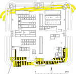
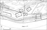
 According to the results of archaeological excavations it was a massively fortified
stronghold covering the area of more than 3 hectares. Its ground plan in
a form of a regular square with rounded corners with inner area of 172
x 172 m followed the cardinal points. The crenellated stonewalls reached
at least 4-5 m in height. On the rear side they were reinforced by an earth
bank, which at the same time created a walkway all around. In the middle
of each side of the fort there was an entrance gate protected by a pair
of towers. The main south gate (porta decumana) at the shore of the Danube
enabled a vital connection to the mother legionary camp at Brigetio.
According to the results of archaeological excavations it was a massively fortified
stronghold covering the area of more than 3 hectares. Its ground plan in
a form of a regular square with rounded corners with inner area of 172
x 172 m followed the cardinal points. The crenellated stonewalls reached
at least 4-5 m in height. On the rear side they were reinforced by an earth
bank, which at the same time created a walkway all around. In the middle
of each side of the fort there was an entrance gate protected by a pair
of towers. The main south gate (porta decumana) at the shore of the Danube
enabled a vital connection to the mother legionary camp at Brigetio. 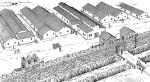 It had a double-carriageway structure with a central buttress. The gate towers
were of a rectangular ground plan and they partially protruded from the
defensive wall line. The roads in carriageways were reinforced by small
rubble. The north gate (porta praetoria) facing a potential enemy had just
a single carriageway. Angle towers as well as interval towers placed between
the corners and gates leaned on the defensive wall from inside. The fort’s
defensibility was still strengthened by the rings of two V-shaped ditches
and ramparts enclosing it from three sides.
It had a double-carriageway structure with a central buttress. The gate towers
were of a rectangular ground plan and they partially protruded from the
defensive wall line. The roads in carriageways were reinforced by small
rubble. The north gate (porta praetoria) facing a potential enemy had just
a single carriageway. Angle towers as well as interval towers placed between
the corners and gates leaned on the defensive wall from inside. The fort’s
defensibility was still strengthened by the rings of two V-shaped ditches
and ramparts enclosing it from three sides.
The build-up of this fortress was extremely difficult because the Romans
had to transport almost all the building material – large volumes of
stone, lime, timber, brick products – by ships from the opposite Danube
bank. As testified by the majority of brick name stamps, the build-up
of the fort was performed mainly by the Legio I Adiutrix (auxiliary)
from Brigetio. However, bricks had been transported on the Danube also
from far away.
So far, interior building plan of the fort is known mainly from the older excavations.
According to the traditional Roman scheme, its two main axes were followed by
main roads (via
decumana and via principalis) connecting two opposite gates.
However, the headquarters building wasn not located, as usually, in the centre
of the camp at the intersection of these roads but it was atypically shifted
next to the west gate of the fort. The baths were placed in the south-eastern
part of the fort area. According to the characteristic ground plan with supporting
piers, the longitudinal constructions by the northern defensive wall can be held
for granaries (horrea). The other buildings arranged into a street system served
as barracks and stables.
In the south-western part of the fort some traces of another barrack building
were recently discovered. Its function is indicated by its rectangular ground
plan divided by several partitions into two rows of rooms that served for the
accommodation of a garrison. Until now up to 30 m of its length was excavated.
Only one wall footing of one partition was preserved in the original condition.
It is represented by dry limestone masonry laid into a basement furrow. The
floor level of rammed clay could have been detected just in two rooms. The
barrack walls were presumably built of timber or by a technique of timber frame-work
with adobes. The building probably burnt down around the mid-3rd century.
In this part of the fort also the remnants of two large bread ovens and several
wells were uncovered, constructed in similar manner as in another Roman camps.
After a circular shaft was excavated and the ground-water level achieved, they
used rejected wooden barrels for timbering. Then the upper part of the well shaft
was stone-faced from inside. Analyses of the barrel remnants revealed they were
made of pine and fir wood.
The garrison of the fort was fully dependent on the supply of food, raw materials and other products from Brigetio and the adjacent part of Pannonia. It is testified by the articles of daily use for food storage, preparation and serving of meals, lighting, but also by animal bones and charred plant macro remains. The majority of household ceramics – kitchen and table ware (pots, lids, jars, beakers, bowls and plates) comes from Brigetio. Most numerous are ceramic vessels manufactured in local pottery workshops. Although more luxurious ware was also manufactured there, demand of the army for high-quality table ceramic could not be satisfied only from this source. It was supplied above all by the import of terra sigillata from the West Roman provinces (Gallia, Germania, Raetia). The supply of Brigetio and its bridgehead with this ceramics culminated under the Severans (end of the 2nd – beginning of the 3rd century) when the ware from the well-known centres in present-day Germany was flowing in (Rheinzabern, Westerndorf). During this period Brigetio also played an important role in transmitting terra sigillata to its wider bridgehead occupied by the Quadi.
Further destiny of the fort in the second half of the 3rd century is not known as yet. Neither is it the name of the military unit that created the garrison of this advanced Roman Limes fortress. Similarly, the antique name “Kelemantia”, by which this Roman fort was denominated according to the antique geographer Klaudios Ptolemaios, is still uncertain. Distinct traces of the fortification rebuildings come from the 4th century.
Ján Rajtár
KUZMOVÁ, K./RAJTÁR, J. 1986: Bisherige Erkenntnisse zur Befestigung des Römerkastells in Iža. Slovenská Archeológia 34, 185-222.
RAJTÁR, J. 1992: Das Holz-Erde-Lager aus der Zeit der Markomannenkriege in Iža. In: Probleme der relativen und absoluten Chronologie ab Laténezeit bis zum Frühmittelalter (Kraków), 149-170.
RAJTÁR, J. 1995: Waffen und Ausrüstungsteile aus dem Holz-Erde-Lager von Iža. Journal of Roman Military Equipment, Vol. 5, 1994 (Oxford), 83-95.
SVOBODA, B. 1962: K dějinám římského kastelu na Leányváru u Iže, okres Komárno. Slovenská archeológia 10, 397-424.