Siehe diesen Text auf ![]()
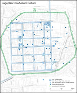
Based on the intensive excavations which have taken place since 1988, today the location of Aelium Cetium can be proven to be practically identical in area with the mediaeval town centre of St. Pölten. Archaeological finds begin with sporadic evidence from the late 1st c. A.D., while for many areas of the peripheral insulae construction first begins around the middle of the 2nd c. A.D. The foundation is more likely to date to the reign of Hadrian than to that of Antoninus Pius, and has been connected with the inspection tour undertaken by Hadrian through Noricum in 121/122 A.D. Although numerous prehistoric finds are known from the area of the city, a late Latène settlement directly preceeding the Roman one can with certainty be ruled out. The name of the town is related to the designation of the Wienerwald massif as the ‘mons Cetius’ (= wooded mountain). On a number of inscriptions, the administrative offices of the duumvir iure dicundo, aedilis and questor, as well as the ordo decurionum and the priestly office of the flamen are named.
The city served as the primary civilian support and administration centre of north-east Noricum (Lower Austria, region beyond the Wienerwald), and was located at the intersection of the main east-west route through the Alpine foreland with the Traisen (attested epigraphically: Tragisamus), a day’s march away from the Danube border, which had been secured since the Flavian-Trajanic period with 6 auxiliary troop camps in accessible proximity. The main duties of the city were to provide this region with supplies, and also to deliver military equipment, as evidenced by half-finished products from forges. There was never a garrison in the region of the city itself.
Building Phase 1 came to an end in nearly every excavated area with an area conflagration, which can be connected to the Marcomanni attack in the year 170. An additional extensive destruction horizon can be dated approximately to the post-Severan period (ca. 240).
The built-up area enclosed roughly a square with 500 m. to a side, or 25 ha. As a typical example of a planned city, Cetium possessed a grid street system oriented almost exactly to the cardinal points, with insulae with regular north-south dimensions of ca. 66 m., and between 55 and more than 95 m. in width. All of the known streets were 6 m. wide on average, with a cambered gravel surface with side trenches which were generally uncovered; only one cardo was fitted with a walled drain built at a later date and running along its west side. In many locations, the existence of porticoes with wooden columns, between the street trenches and the houses, can be demonstrated on at least one side of the street. Compared to the rest of the city plan, the orientation of the built structures in the easternmost area of the town appears to have altered direction, seemingly oriented to the edge of a tract of land on the border of the flood plain of the Traisen or to a street which hypothetically ran past here.
 |
 |
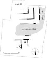
The widest insula row, lying slightly to the east of the city centre and to the west of the assumed cardo, is the site of all known public buildings. The two central insulae can be interpreted as the Forum and as an area sacra. The Forum north of the decumanus maximus is identifiable only through epigraphic finds, including a Neptune altar of a governor (ca. 270 A.D.) and the building inscription of the club house of the association of the collegium fabrum; furthermore, the fact that this area served as the mediaeval market place of St. Pölten underscores this identification. Excavations have not taken place here. Based on epigraphic evidence, the meeting house of the association of smiths was reconstructed a few years after the destruction of the city by the Marcomanni in ca. 170 A.D., during the sole rule of Marcus Aurelius.
Excavations in the adjacent insula to the south brought to light the south-east corner of a double portico, each aisle having a clear breadth of ca. 3.60 m. The exterior aisle opened on to the surrounding streets, the inner on to a piazza in the centre of which the main temple of Cetium was probably located.
In the northernmost building block of the same insula row, in the course of rescue excavations three large rooms equipped with area floor heating were cut into; the largest of these was 20 m. in length. The rooms probably belonged to a bathing complex which must have more or less taken up the entire building block.
In the north-easternmost insula (excavation area in the Klostergarten/monastery garden), between two houses at the northern perimeter, a two-roomed stone building richly decorated with wall paintings and furnished with underfloor heating was located. Built on to this on the garden side was a temple in antis (6.6 x 2.5 m.) open to the east and with a vestibule and cella. On the basis of the few relevant archaeological finds, for example a vessel decorated with applied snakes, the building is probably to be interpreted as the meeting hall of an association which worshipped the cult of oriental gods.
The domestic buildings consist throughout of free-standing single residences of greatly differing sizes and construction types. Closed-in insulae with surrounding walls only become more common in the late imperial period. Due to the fact that the building stones were frequently robbed for other uses in the late antique, mediaeval and contemporary periods, the residential structures are in a very poor state of preservation. Structures of pure wood are uncommon, although in a few places there is evidence of such constructions, connected with the foundation phase of the city. Wooden framework structures with masonry socles with a height of up to 1.10 m. formed the most common house type for the 2nd and 3rd centuries; without exception, these possessed an upper storey. For Building Phase 1, single heated rooms in the houses are uncommon, while floor mosaics, polychrome wall painting or other decoration are extremely rare indeed. All of the living rooms had floors of stable terrazzo, in the side rooms and porticoes the floors were of beaten loam. To date, interior cellars have not been identified anywhere, although in the area of the courtyards, several simple earth cellars (ca. 2 x 3-4 m.) existed. Small garden areas enclosed by walls, and workers’ yards with kilns and smelting furnaces, were located in all districts of the city.
In the west (excavations near the Rathaus/Town Hall), an insula north of the decumanus maximus, which was partially investigated in 1988, seems to have been divided by three strips into three parcels of land, each measuring ca. 15 x 30 m. (50 to 100 feet); a further subdivision into units half this size is also identifiable. The individual parcels of land were occasionally divided by 1.5 m. wide gravel pathways. The central land tract remained undeveloped and served as the location of a pottery kiln.
A considerably smaller insula in the north-east of the city (Klostergasse) seems to have been divided up originally into 2 x 3 parcels of land lying next to each other, of identical size, and separated by fences and walls.
 |
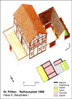 |
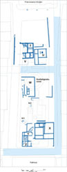
The best-studied of the houses, House X on the Rathausplatz/Town Hall Square, in Building Phase 1 (ca. 145-170) resembled a farm house on the edge of the town. The main building had three rooms laid out parallel in a width ratio of 1: 2: 1, without a passageway; across their entire width at the front facing the street lay an unwalled work yard. Inside the walled-in central court were located a one-roomed structure which was slightly sunken into the ground, an open colonnade, and at the back an unfenced garden.
Two houses (18.80 x 6.4 m.) which originally had three rooms, dating to the 2nd c. A.D. and very similar in their central tract to House X, have been identified in the south-east of Cetium (Steinergasse, Houses A and B), while two additional houses have been identified in the north-east (Klostergarten, Houses 4 and 5). Therefore these rectangular houses with a single row of rooms constituted the most common house type at Cetium.
 Houses of a quite different design have
also been excavated not only at the Rathausplatz but also in the Klostergarten;
in general, these conform to the so-called Block Type with roughly square groundplan
and three rows of rooms, or a large central kitchen with hearth and surrounding
smaller rooms and passageways. House 3 in the Klostergarten represents a special
case: it lay at a street intersection, and on both of the other sides was surrounded
by a heavily gravelled courtyard area. Towards the south, a possibly open colonnade
with loam floor opened out, behind which were three narrow rooms also with
loam floors. Here we are apparently dealing with a commercial tract complete
with portico and three tabernae or shops. The living quarters were located
in the northern half of the house, and consisted of four small rooms, one of
which was already heated in Building Phase 1, and a larger room at the corner.
Houses of a quite different design have
also been excavated not only at the Rathausplatz but also in the Klostergarten;
in general, these conform to the so-called Block Type with roughly square groundplan
and three rows of rooms, or a large central kitchen with hearth and surrounding
smaller rooms and passageways. House 3 in the Klostergarten represents a special
case: it lay at a street intersection, and on both of the other sides was surrounded
by a heavily gravelled courtyard area. Towards the south, a possibly open colonnade
with loam floor opened out, behind which were three narrow rooms also with
loam floors. Here we are apparently dealing with a commercial tract complete
with portico and three tabernae or shops. The living quarters were located
in the northern half of the house, and consisted of four small rooms, one of
which was already heated in Building Phase 1, and a larger room at the corner.
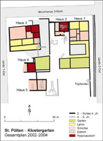
House 1 in the Klostergarten encompassed a total unwalled area of 28.4 x 12.2 m. To the north, at the street corner, were two open courtyards for commercial use, one of which was furnished with a cistern and a furnace. The living tract, with an area of 60 m² divided into two large rooms and three small chambers, was relatively modest. The southern courtyard (total area 11.2 x 9.8 m.), which was surrounded on three sides by a 1.5 – 1.8 m. deep portico, was, by contrast, almost twice as large. An unwalled garden formed the southern limitation of the property.
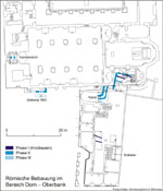
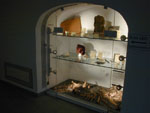
Until today, it has not been possible to preserve and display archaeological finds in their original location. In a few locations, however, vitrines with finds and descriptive diagrams have been set up, for example in the houses at Wiener Straße 14, Domplatz 2 (Oberbank) and Lederergasse 8-10.
Exhibitions regarding the excavation results in St. Pölten can be viewed at the Stadtmuseum (Prandtauerstraße 2) and in the Diözesanmuseum (Domplatz 1). In the foyer of the Rathaus, a small lapidarium is on view.
S. Jilek — P. Scherrer — E. Trinkl,
Leben in Aelium Cetium. Wohnen und Arbeiten im römischen St. Pölten, Sonder- und Wechselaussstellungen der NÖ Landesbibiliothek 26 (2005)
R. Risy, Aelium Cetium - St. Pölten. Zur hochmittelalterlichen Stadtbildung auf römischen Ruinen, in: Zwischen Römersiedlung und mittelalterlicher Stadt. Archäologische Aspekte zur Kontinuitätsfrage. Beiträge zur Mittelalterarchäologie in Österreich 17, 2001, 169–178.
R. Risy, Der Dom in St. Pölten und seine Vorgeschichte im Lichte der jüngsten Forschungen, in: T. Aigner et al., C. R. Y. Festschrift zum 75. Geburtstag von H. Fasching (2004) 418–433.
R. Risy — P. Scherrer, Municipium Aelium Cetium – Landeshauptstadt St. Pölten. Archäologische Grabungen und Forschungen 1999–2005, Hippolytus, Neue Folge. St. Pöltner Hefte zur Diözesankunde, 5. Beiheft (2005)
R. Risy — P. Scherrer — E. Trinkl, Das antike Aelium Cetium – Stadtarchäologie in St. Pölten, in: Forum Archaeologiae 34/III/2005; http://farch.net.
P. Scherrer (Hrsg.), Landeshauptstadt St. Pölten – Archäologische Bausteine. Sonderschriften des Österreichischen Archäologischen Institutes 22 (1991) (mit ausführlicher Bibliographie).
P. Scherrer (Hrsg.), Landeshauptstadt St. Pölten – Archäologische Bausteine II. Sonderschriften des Österreichischen Archäologischen Institutes 23 (1994).
P. Scherrer, St. Pölten – Landeshauptstadt aus römischen Wurzeln. Ergebnisse der Stadtarchäologie 1988–1998 (1998).
P. Scherrer, Systematische Stadtarchäologie: Fallbeispiel Aelium Cetium – St. Pölten, Niederösterreich, in: The Roman Town in a Modern City. Proceedings of the International Colloquium held on the occasion of the 100th Anniversary of the Aquincum Museum 1994 Budapest, hrsg. v. M. Németh, Aquincum Nostrum II (1998) 29–34.
P. Scherrer, Die Archäologie des Siedlungsraumes St. Pölten vom Neolithikum bis zum Ende des Frühmittelalters, in: Österreichische Kunsttopographie LIV: Die Kunstdenkmäler der Stadt St. Pölten und ihrer eingemeindeten Ortschaften, hrsg. vom Bundesdenkmalamt, bearbeitet von Th. Karl, H. Karner, J. Kronbichler, Th. Pulle, unter Mitarbeit von R. Gamsjäger, G.A. Stadler, P. Scherrer (1999) XIX–LXII.
P. Scherrer, Aelium Cetium – St. Pölten. Ein Beitrag der Stadtarchäologie zum römischen Erbe in der mittelalterlichen Stadtentwicklung, in: Chr. Rohr (Hrsg.), Vom Ursprung der Städte. Jubiläumsschrift zur 1200. Wiederkehr der Erstnennung von Linz (1999) 43–60.
P. Scherrer mit Beiträgen von M. Kronberger und W. Szaivert, Cetium, in: M. Šašel Kos – P. Scherrer (Hrsg.), The Autonomous Towns in Noricum and Pannonia – Die autonomen Städte in Noricum und Pannonien: Noricum, Situla 40 (2002) 213–244.
H. Ubl, Die Skulpturen des Stadtgebietes von Aelium Cetium, Corpus Signorum Imperii Romani, Österreich I 6 (1979).