Lees deze text in ![]()
Julius Caesar
 The
people living
in what is now the Netherlands first encountered the Romans during
Julius
Caesar’s military campaigns around 50 BC. Caesar probably never got any
further
than the Dutch riverine area. The Netherlands’ wet peat and clay were
fairly
inaccessible for a large army. Furthermore, he faced problems with the
population in present-day northern France, Belgium and the Netherlands.
The
Eburones were a good example. In c. 53 BC they destroyed a Roman army
camp.
Caesar avenged this act by virtually annihilating the entire tribe,
leaving
large areas of land almost deserted. He left behind no occupying force
after he
returned to the south.
The
people living
in what is now the Netherlands first encountered the Romans during
Julius
Caesar’s military campaigns around 50 BC. Caesar probably never got any
further
than the Dutch riverine area. The Netherlands’ wet peat and clay were
fairly
inaccessible for a large army. Furthermore, he faced problems with the
population in present-day northern France, Belgium and the Netherlands.
The
Eburones were a good example. In c. 53 BC they destroyed a Roman army
camp.
Caesar avenged this act by virtually annihilating the entire tribe,
leaving
large areas of land almost deserted. He left behind no occupying force
after he
returned to the south.
Ceasars successor, emperor Augustus, made another
attempt,
however. He sent several generals on campaigns to finally conquer the
northern
areas. The first Roman military camp in our country was probably built
during
one of these campaigns: an exceptionally large legionary camp at
Nijmegen,
built between 19 and 15 or 12 BC.
Roman control?
 It
was general
Drusus who finally managed to bring the countries to the south of the
Rhine
under Roman control, 40 years after Caesar’s campaigns. Military camps
along
the Rhine served as a base for his campaigns into northern areas.
Initially
things went fairly well. Almost all the inhabitants of the present-day
Netherlands submitted more or less willingly to Roman authority.
However, in AD
9, at the famous Battle of Teutoburg Forest, near present-day Osnabrück
(Germany), indigenous tribes defeated three entire Roman legions.
Thereafter
the areas to the north of the Rhine were left more or less in peace.
The
conquered areas were placed under a military administration based in
Vetera, a
military site near Xanten (Germany). The administration of the newly
conquered
area was based in Cologne, which would later become the capital of the
new
province. The Romans then only concerned themselves with a few tribes
north of
the Rhine that had been conquered and paid taxes. In AD 28 the
Frisians, who
lived on the coast, revolted against Roman taxation. The rebellion was
quashed,
but not before the Romans suffered heavy losses. From that moment on,
the Rhine
became an ever clearer boundary between Roman territory and the
‘Barbarians’,
as the Romans called the peoples of unconquered regions. The fortresses
that
had been built along the Rhine thus became frontier fortifications, and
more were
added around AD 40. Some of the new fortresses probably served not only
as
defences for the river and the hinterland beyond, but also as a supply
point
for troops sent to conquer England. In AD 47 emperor Claudius decided
to
withdraw the army from the areas north of the Rhine, formalising the
river’s
status as the border of the Roman empire. When Claudius had to recall
his
general Corbulo to the south, the Roman empire lost the Frisians’
territory,
which the general had only just brought under control. In AD 69/70 the
peace
was once again rudely disturbed by the Batavian revolt, though after
that
things remained peaceful for a long time.
It
was general
Drusus who finally managed to bring the countries to the south of the
Rhine
under Roman control, 40 years after Caesar’s campaigns. Military camps
along
the Rhine served as a base for his campaigns into northern areas.
Initially
things went fairly well. Almost all the inhabitants of the present-day
Netherlands submitted more or less willingly to Roman authority.
However, in AD
9, at the famous Battle of Teutoburg Forest, near present-day Osnabrück
(Germany), indigenous tribes defeated three entire Roman legions.
Thereafter
the areas to the north of the Rhine were left more or less in peace.
The
conquered areas were placed under a military administration based in
Vetera, a
military site near Xanten (Germany). The administration of the newly
conquered
area was based in Cologne, which would later become the capital of the
new
province. The Romans then only concerned themselves with a few tribes
north of
the Rhine that had been conquered and paid taxes. In AD 28 the
Frisians, who
lived on the coast, revolted against Roman taxation. The rebellion was
quashed,
but not before the Romans suffered heavy losses. From that moment on,
the Rhine
became an ever clearer boundary between Roman territory and the
‘Barbarians’,
as the Romans called the peoples of unconquered regions. The fortresses
that
had been built along the Rhine thus became frontier fortifications, and
more were
added around AD 40. Some of the new fortresses probably served not only
as
defences for the river and the hinterland beyond, but also as a supply
point
for troops sent to conquer England. In AD 47 emperor Claudius decided
to
withdraw the army from the areas north of the Rhine, formalising the
river’s
status as the border of the Roman empire. When Claudius had to recall
his
general Corbulo to the south, the Roman empire lost the Frisians’
territory,
which the general had only just brought under control. In AD 69/70 the
peace
was once again rudely disturbed by the Batavian revolt, though after
that
things remained peaceful for a long time.
A new province
 Until
almost the
end of the first century AD this region officially remained under
military
authority. It was not until somewhere between AD 82 and 90 that the
region to
the west and south of the Rhine became a province: Germania Inferior.
The new
province was an elongated territory extending from the small river
Vinxtbach
(to the south of Bonn) to the North Sea. The exact position of the
southern
border, to the south of present-day Belgium, is not known. The only
thing we
have to go on is the fact that the Menapii, who must have lived in the
coastal
area of northern Belgium and the Dutch province of Zeeland, did not
live in
Germania Inferior but in Gallia Belgica. The southern border of
Germania
Inferior probably ran through present-day Noord-Brabant or the north of
Belgium. The Roman province of Germania Inferior thus lay in
present-day
Germany, the Netherlands, and probably part of Belgium.
Until
almost the
end of the first century AD this region officially remained under
military
authority. It was not until somewhere between AD 82 and 90 that the
region to
the west and south of the Rhine became a province: Germania Inferior.
The new
province was an elongated territory extending from the small river
Vinxtbach
(to the south of Bonn) to the North Sea. The exact position of the
southern
border, to the south of present-day Belgium, is not known. The only
thing we
have to go on is the fact that the Menapii, who must have lived in the
coastal
area of northern Belgium and the Dutch province of Zeeland, did not
live in
Germania Inferior but in Gallia Belgica. The southern border of
Germania
Inferior probably ran through present-day Noord-Brabant or the north of
Belgium. The Roman province of Germania Inferior thus lay in
present-day
Germany, the Netherlands, and probably part of Belgium.
Attacks on the empire
Until the end of the second century AD it remained peaceful in the province, allowing its economy and culture to flourish. However, from around AD 175 onwards, Germanic groups from north of the Rhine made more and more frequent incursions into the prosperous Roman empire, destroying a number of military posts and plundering settlements. The military posts were rebuilt, however, and the peace seemed to be restored.
Roman citizens
In AD 212 emperor
Caracalla granted all free inhabitants of the empire Roman citizenship.
This
was a right to which not all had been entitled previously. Now that
everyone
enjoyed Roman civil rights, the ‘Romanisation’ of the northern
provinces was in
theory complete. However, this did not necessarily mean that everyone
had
adopted a Roman way of life.
The
Pax Romana, or
‘Roman Peace’, would not last much longer. The province increasingly
fell
victim to plundering Germanic tribes. Other problems also arose in
Germania
Inferior and in Rome itself. The border along the Rhine had in fact
already
come under attack in around 275. The hinterland was under threat, but the
Romans kept things going as well as they possibly could. At the
beginning of
the fifth century AD, however, they were no longer able to restore
order, and
Roman rule along the Rhine finally came to an end.
Bloody encounters
It is
difficult to
say with certainty who exactly lived in what is now the Netherlands at
the time
of the first Roman campaigns to these parts. Most of our information
comes from
the writings of Caesar, Strabo, Pliny the Elder, Tacitus, Ptolemy and
Cassius
Dio, who tell of a small-scale migration after Caesar’s military
campaigns.
During these campaigns part of the population had been wiped out,
leaving their
lands empty and unoccupied. One example is the territory inhabited by
the
Eburones, whom Caesar had virtually annihilated in 52 BC after they had
attacked a Roman military camp. The almost entirely deserted area that
had been
occupied by the Eburones probably lay roughly in present-day Brabant,
Limburg
and Belgium. In the last half-century BC more and more groups crossed
the Rhine
to live in the almost deserted lands. They probably moved with the
permission
and perhaps even at the instigation of the Romans, who preferred to
have
friendly tribes living in these empty areas. The newcomers mixed with
what was
left of the local population to form new tribes with new names. In the
later
Roman province civitates were
established, Roman administrative units roughly based on the old tribal
areas.
Since the names of the civitates are known, we also know the names of
the
tribes and their territories.
Who lived where?
Thanks
to ancient
writings, we know the names of three tribes and their territories for
certain:
the Batavians of the river-area, the Cananefates along the coast of
Zuid-Holland and the Cugerni in northern Limburg and neighbouring areas
of
Germany. We also know there were tribes called the Texuandri, Tungri,
Marsaci,
Sturii, Frisiavones and Baetasii. The Texuandri probably lived between
the Maas
and Demer rivers, in the border area between the Netherlands and
Belgium. The
Marsaci, Sturii and Frisiavones are generally placed to the south of
the Maas
estuary in the current province of Zeeland and the western part of
Brabant. The
Baetasii were probably a sub-tribe of the Cugerni, whose capital was
Xanten in
Germany. They are generally located to the area between the Maas and
Rhine, in
the border area between Limburg province and Germany. The Tungri lived
around
their capital, the present-day Belgian town of Tongeren. They were
therefore
probably the southern neighbours of the Texuandri, who might indeed
have been a
sub-tribe of the Tungri. The Romans probably assigned the Tungri to the
province of Gallia Belgica, so they would not have belonged to Germania
Inferior like the other tribes mentioned here. However, we are not
entirely
certain which tribe belonged to which province, and it is currently
unclear
whether new population groups also moved into the area to the north of
the
Rhine. We only know of the Frisii of present-day Noord-Holland and the
Chauci
from the Dutch and German coastal region. The Amsivarii and Chamavi
also most
probably lived somewhere to the north of the Dutch Rhine, although they
are
known only by name.
The
new people, who would later be called the Batavians, formed part of the
Chatti
tribe of northern Germany before moving to our region. They moved soon
after
the defeat of the Eburones. It was not until much later, around 8 BC,
that
small groups of Sugambri crossed the Rhine. They had been defeated by
Tiberius
and were forced to move to the left bank, probably becoming the Cugerni
and
Baetasii.
The famous Batavians
The
Batavians are
by far the most well-known inhabitants of the Roman Netherlands. The
majority
of their territory was known as Insula Batavorum, or ‘Island of the
Batavians’.
According to Tacitus, this was the area between the Rhine and Waal
rivers and
the sea. However, they probably also inhabited the southern bank of the
Maas,
in the current province of Noord-Brabant. The Batavians had a special
status
from the very beginning. They were exempt from normal taxes, though in
exchange
they did have to supply troops, among other things. The Batavian troops
were
highly prized for their courage and military skills. Until the Batavian revolt
they served as bodyguards for the emperor in Rome, for example. Even
after the
revolt they were able to retain some of their rights. At various
military sites
along the northern border, and also in Rome itself, gravestones and
other
inscriptions have been found with the names of Batavians and the
military unit
in which they served. We therefore know a large number of Batavian
names.

The
tribes living
in the Netherlands did not automatically submit to Roman rule, as
evidenced by
two revolts in the first century AD: the Frisian and the Batavian
revolts.

The
Frisian
revolt, in AD 28, may be less well known than the Batavian Revolt, but
it is no
less fascinating. The Roman author Tacitus gives a fairly extensive
account of
the event in his Annals (IV 72-72). The Roman procurator decided to
demand more
cattle skins than the Frisians had hitherto supplied. He also
specifically
wanted the hides of aurochs, which were much larger than domesticated
cattle.
The Frisians were unable to meet his demands. Tacitus wrote in his
Annals:
‘First it was their herds, next their lands, last, the persons of their
wives
and children, which they gave up to bondage’. Tacitus is probably
exaggerating
here, though the tax was at any rate so high that the Frisians
revolted. The
soldiers who came to collect the hides were ‘seized and gibbeted’, and
Olennius
fled to the Roman fortress of Flevum (near modern-day Velsen). The
distribution
of the Romans’ slingshot has allowed archaeologists to piece together
the
progress of the battle for the fortress. As time went on, and their
best slingshot
was used up, the Romans were forced to improvise. They melted lead on
the
battlefield and cast it in pits in the sand which they made using their
index
finger. Fingerprints of Roman soldiers can be seen on some of the
slingshot
that has been found. Military units from other parts of Germania came
to
relieve the fortress. After a bitter battle the Frisians managed to
drive them
away. ‘Soon afterwards it was ascertained from deserters that nine
hundred
Romans had been cut to pieces in a wood called Baduhenna's, after
prolonging
the fight to the next day, and that another body of four hundred, which
had
taken possession of the house of one Cruptorix, once a soldier in our
pay,
fearing betrayal,
had perished by mutual slaughter’ (Tacitus Annales, IV, 73).
The location of Baduhenna’s wood and the house of Cruptorix is still
the
subject of debate.
The Batavian revolt
The
Batavian
revolt occurred in AD 69/70. The immediate cause probably lay in the
fact that
the Batavians were obliged to supply too many troops. However, the
feeling that
they were being forced into a Roman way of life was a more important
factor.
The Batavians therefore went in search of allies to stage a rebellion.
Under
the leadership of Julius Civilis, a Batavian with a long record of
service in
the Roman army, the Batavians, Frisians and Cananefates launched an
attack on a
number of border fortresses. Many troops in the Roman army,
particularly
Batavian troops, defected to join the rebels. The revolt quickly spread
as
other Germanic and Gallic tribes joined the Batavians. However, emperor
Vespasian sent more legions and eventually succeeded in suppressing the
revolt.
Many fortresses and other Roman structures had been burnt down. Even
after the
revolt the Batavians retained most of their former privileges, though
Batavian
soldiers would henceforth be stationed far from home so that they could
not
help in any future revolt. Hundreds of years later, in the late 18th
century,
the Batavian revolt was to inspire rebellious patriots who resisted the
authorities
of the time and eventually proclaimed the Batavian Republic. As a
result of its
great impact on later Dutch history several detailed
accounts exist of the
Batavian revolt.
 In the early first
century AD the Netherlands was the scene of several military campaigns
to the
north. The Rhine was used as a base, with soldiers travelling from
there via
the Vecht to the Flevomeer and Waddenzee. They then made incursions
from the
north into Germanic areas in present-day Germany along the Eems, Weser
and Elbe
rivers. Nijmegen had a legionary fortress that could house two legions
(2 x
6400 men, so almost 13,000 troops). There are indications that this
military
site dates from the period 19-15/12 BC, which means that there were
troops in
Nijmegen before the infamous military campaigns of Drusus’ army.
Unfortunately,
however, the historical sources make no mention of this. Around the
beginning
of the present era camps were also built in Velsen, Vechten and Arnhem.
The exceptionally
large legionary fortress (castra) in Nijmegen was a mustering point for
the
troops. It was the only legionary fortress on the territory that is now
the
Netherlands.
In the early first
century AD the Netherlands was the scene of several military campaigns
to the
north. The Rhine was used as a base, with soldiers travelling from
there via
the Vecht to the Flevomeer and Waddenzee. They then made incursions
from the
north into Germanic areas in present-day Germany along the Eems, Weser
and Elbe
rivers. Nijmegen had a legionary fortress that could house two legions
(2 x
6400 men, so almost 13,000 troops). There are indications that this
military
site dates from the period 19-15/12 BC, which means that there were
troops in
Nijmegen before the infamous military campaigns of Drusus’ army.
Unfortunately,
however, the historical sources make no mention of this. Around the
beginning
of the present era camps were also built in Velsen, Vechten and Arnhem.
The exceptionally
large legionary fortress (castra) in Nijmegen was a mustering point for
the
troops. It was the only legionary fortress on the territory that is now
the
Netherlands.
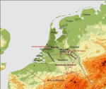
The
border of the
Roman empire – the limes – was not finally drawn until AD 47, along the
Rhine:
the current Nederrijn, Kromme Rijn and Oude Rijn. The fortresses along
the
border were known as castella, built to house a cohort (16 x 32 men),
an ala (6
x 80 cavalrymen) or a combination of the two. They were thus much
smaller than
the legionary fortress in Nijmegen. Most of these castella were not
built until
the first century AD, mainly along the Rhine, to control one of the
most
important shipping routes. When, in AD 47, emperor Claudius decided to
relinquish the areas to the north of the Rhine, extra castella were
built along
the river. Eventually, there were 20 castella along the Dutch section
of the
Rhine.
 |
 |
 |
The
Romans
preferred to build their castella beside a tributary or old branch of
the
Rhine, rather than along the main river itself, as they had better
locations
for the construction of harbours. It also enabled them to stop invaders
entering the Roman province via a tributary. The castella were linked
by a road
that ran along the Rhine. Watchtowers were situatad at regular
intervals
between the castella to guard the border. Several watchtowers along the
limes
road have recently been excavated at the new Leidsche Rijn residential
development near Utrecht. The excavations have given us a clear picture
of what
the watchtowers would have looked like. There were probably also a
number of
fortresses along the coast. However, we know little about them as they
have
been eroded away by the sea.
A
military fleet –
the classis Germanica – was stationed on the Rhine. The fleet’s main
base was
in Alteburg, close to the provincial capital Cologne, but there were
probably a
number of smaller bases near to a number of Dutch castella. Their task
was to
keep the Rhine navigable for both military and trading vessels. They
also
guarded the tributaries in ‘enemy’ territory. In peacetime the fleet
was the
biggest freight carrier on the Rhine. Its cargo included large
consignments of
stone from quarries in the Eiffel which it transported downriver to the
military posts in the Netherlands. The name classis Germanica can also
be found
on roof tiles suggesting that, like other parts of the Roman armed
forces, at
least part of the fleet was involved in the production of roof tiles.
Many remains of
the former border of the Roman empire have already been excavated in
the
Netherlands. We therefore know quite a lot about how the limes was
defended.
The new Leidsche Rijn district near Utrecht has proved a treasure trove
of
information about the water border of the empire. Remains of the limes
road,
watchtowers, wharfs and traces of one of the castella were investigated
during
the construction work, revealing among other things remains of
revetments along
the river, which was designed to ensure that the limes road did not
erode into
the river.
There were three
different types of town in the Roman provinces: coloniae, municipia and
vici.
The difference between them lay in their legal status. The coloniae
(colonia in
the singular) were founded by the Romans. These new towns were intended
to
provide a Roman home on foreign territory. The inhabitants of a colonia
had
Roman civil rights, which gave them many privileges. Municipia
(municipium in
the singular) had a slightly lower status. They had been granted
special rights
by the emperor, and were thus allowed to use the title ‘municipium’.
The
inhabitants of municipia were also Roman citizens, although they had
fewer
rights than those who lived in a colonia. Finally, there were towns
with no
special status. However, the fact that they had not been officially
awarded a
city charter or market rights did not stop them from developing into
centres
for their region. The Romans usually called such a town without special
rights
or status a vicus. However, the name was also used for settlements that
we
would now call villages. The title vicus was thus used very generally
to refer
to anything from a village to a town. We therefore prefer to use the
term
‘rural centre’ to refer to towns without any special legal status.
Sometimes
the emperor granted a vicus the right to hold a market. This did not
confer
Roman citizenship on the inhabitants, though the status of their town
would be
enhanced by the market.
There were no coloniae in the Dutch part of Germania Inferior. The nearest colonia was Xanten: Colonia Ulpia Traiana (CUT), which was probably founded in AD 98. There were however two municipia in the Netherlands: Nijmegen and Voorburg. Before it was granted a city charter, Nijmegen was known as Ulpia Noviomagus Batavorum: ‘Ulpic new marketplace of the Batavians’. After officially being designated a municipium, it became known as ‘Municipium Batavorum’. The best-known name for Voorburg is now Forum Hadriani: ‘Hadrian’s Market’. After it was granted a city charter by the emperor, Voorburg became officially known as ‘Municipium Aelium Cananefat(i)um’ (abbreviated to MAC). The Roman towns of Heerlen (Coriovallum) and Maastricht (Traiectum ad Mosam?) were never granted a city charter, though they were sizeable towns compared with the villages and hamlets in the surrounding countryside.
The Netherlands
was probably already an important transit country in Roman times, as it
still
is today. Military and merchant vessels set sail for England from what
is now
Zeeland. The most important shipping routes passed along the Rhine,
Maas and
Scheldt rivers. Smaller rivers were probably also used as transport
routes in
Roman times, despite the fact that they were not so readily navigable.
In
Limburg, for example, the Roer, Geleen and Geul rivers were partly
suitable for
shipping. The Dommel, Reuzel and Beerze might have been used in
Noord-Brabant.
The Romans tried to use these natural transport routes as efficiently
as
possible, making a number of improvements to this end. In Zuid-Holland
province
Corbulo’s canal linked the Maas and Rhine, so that the Romans did not
have to
endure the storms of the North Sea. The canal was dug in the first
century AD
under the leadership of the Roman general Corbulo, probably along the
course of
the Gantel river. A recent study found that the canal silted up in the
course
of the second century AD, making it unnavigable. One of Corbulo’s
predecessors,
Drusus, had had his men construct engineering works half a century
earlier. He
built a dam at the point where the Rhine and the Waal diverge, to
divert water
to the Rhine and ‘Drusus’ Canal’, which was dug at the same time. We do
not
know for certain where this canal lay, but it is believed to be the
upstream
section of the IJssel river.
Shipping
 A cost calculation
shows that it was much cheaper to transport goods by water than over
land,
particularly when it came to bulk goods like building materials and
grain. The
Dutch rivers were probably very busy. A number of very well preserved Roman
ships have been found in the Netherlands, most of them cargo
vessels. The cargo
vessels (flatboats) found in Zwammerdam are world-famous. Several ships
have
also been found in Woerden, one of which was carrying grain. Remains of
the
cargo were still in the hold. Another ship found in Woerden in 2003 was
unique,
in that it was a cargo vessel with both a sail and oars, and space for
twelve
rowers. Pieces of natural stone and brick were found in the hold,
possibly the
remains of its cargo or ballast.
A cost calculation
shows that it was much cheaper to transport goods by water than over
land,
particularly when it came to bulk goods like building materials and
grain. The
Dutch rivers were probably very busy. A number of very well preserved Roman
ships have been found in the Netherlands, most of them cargo
vessels. The cargo
vessels (flatboats) found in Zwammerdam are world-famous. Several ships
have
also been found in Woerden, one of which was carrying grain. Remains of
the
cargo were still in the hold. Another ship found in Woerden in 2003 was
unique,
in that it was a cargo vessel with both a sail and oars, and space for
twelve
rowers. Pieces of natural stone and brick were found in the hold,
possibly the
remains of its cargo or ballast.
 Though a great
deal of transport was by water, roads were not unimportant. They may
have been
just an addition to the waterway network, but in areas where no rivers
flowed
they were the only way of getting from A to B. Many roads probably
followed
routes that were already centuries old. The Romans made some of these
routes
permanent by surfacing the road or digging ditches along the sides.
This was
not always an easy task, particularly in the riverine area, where there
were
many natural obstacles.
Though a great
deal of transport was by water, roads were not unimportant. They may
have been
just an addition to the waterway network, but in areas where no rivers
flowed
they were the only way of getting from A to B. Many roads probably
followed
routes that were already centuries old. The Romans made some of these
routes
permanent by surfacing the road or digging ditches along the sides.
This was
not always an easy task, particularly in the riverine area, where there
were
many natural obstacles.
Roman engineers
 The
road along the
border of the empire passed through both wet and dry areas. In dry
areas, a
layer of gravel would provide an adequate road surface, but in the
wetter clay
and peat areas, measures had to be taken to ensure the road did not
subside or
wash away. In Valkenburg (Zuid-Holland), for example, road foundations
made of
wood, reed mats and gravel have been found. In Vleuten-de Meern (near
Utrecht)
the posts along the side of the road could clearly be seen in an
excavation.
These posts ensured that the road did not subside. Constructing a road
network
required strong central organisation, as materials such as gravel and
wood had
to be brought in from elsewhere. At the same time as the road was being
built,
revetments were probably being constructed along the river, to prevent
the road
from being washed away. Building materials had to be delivered as close
as
possible to the spot where they were needed. In Leidsche Rijn near
Utrecht the
remains of a 20-metre quayside have been found, which was probably used
for
unloading ships. The limes road runs directly along the quayside, so
the
material could be used directly for laying the road.
The
road along the
border of the empire passed through both wet and dry areas. In dry
areas, a
layer of gravel would provide an adequate road surface, but in the
wetter clay
and peat areas, measures had to be taken to ensure the road did not
subside or
wash away. In Valkenburg (Zuid-Holland), for example, road foundations
made of
wood, reed mats and gravel have been found. In Vleuten-de Meern (near
Utrecht)
the posts along the side of the road could clearly be seen in an
excavation.
These posts ensured that the road did not subside. Constructing a road
network
required strong central organisation, as materials such as gravel and
wood had
to be brought in from elsewhere. At the same time as the road was being
built,
revetments were probably being constructed along the river, to prevent
the road
from being washed away. Building materials had to be delivered as close
as
possible to the spot where they were needed. In Leidsche Rijn near
Utrecht the
remains of a 20-metre quayside have been found, which was probably used
for
unloading ships. The limes road runs directly along the quayside, so
the
material could be used directly for laying the road.
On the orders of the emperor
Dendrochronological
analysis of wooden posts from a number of sections of road has shown
that there
were several major roadbuilding campaigns, during which roads were
repaired and
re-laid where necessary. It seems that the orders to repair the roads
were
always given after the emperor had visited that particular part of the
limes.
In AD 98 Traianus visited the Low Countries, after which a major
roadbuilding
operation was launched. In 122 his successor Hadrian also ordered a
roadbuilding campaign.
Building bridges
 Remains of several
bridges have been found in the Netherlands. The best-known Roman
bridges in
this country spanned the Maas in Cuijk and Maastricht. Remains of
bridge
supports were found there during dredging work, and divers have since
documented the remains in detail. The supports were made of wooden
posts and
natural stone. The wooden piles were encased in metal sheaths. Many of
the
posts have rotted away, but the metal sheaths have been preserved,
allowing the
precise position of the bridge to be identified. During an excavation
of clay
pits in Zuilichem in 1895 a large number of diagonal wooden posts were
found,
which would have supported a wooden bridge. The remains are unique in
that they
come from a bridge built completely of wood, with no stone supports.
The
precise dating of the remains is unknown, but they are believed to
belong to
the Roman period.
Remains of several
bridges have been found in the Netherlands. The best-known Roman
bridges in
this country spanned the Maas in Cuijk and Maastricht. Remains of
bridge
supports were found there during dredging work, and divers have since
documented the remains in detail. The supports were made of wooden
posts and
natural stone. The wooden piles were encased in metal sheaths. Many of
the
posts have rotted away, but the metal sheaths have been preserved,
allowing the
precise position of the bridge to be identified. During an excavation
of clay
pits in Zuilichem in 1895 a large number of diagonal wooden posts were
found,
which would have supported a wooden bridge. The remains are unique in
that they
come from a bridge built completely of wood, with no stone supports.
The
precise dating of the remains is unknown, but they are believed to
belong to
the Roman period.
Milestones

Milestones
that
would have stood alongside Roman roads have been found in a number of
places.
They indicate the distance to the next settlement. In the Wateringse
Veld
district near The Hague, four were found together in a ditch. They
showed not
only the distance but also the name of the emperor who had ordered that
they be
placed there, giving us a precise age for the milestones. The stones
from near
The Hague were placed along the road to MAC – Municipium Aelium (or
Aurelium?)
Canenefatium, the town currently known as Voorburg – in the reigns of
four
different emperors between AD 151 and 250.
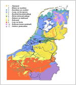
The
Netherlands
was in the Roman province of Germania Inferior, which extended from the
Vinxtbach river near Bonn to the North Sea coast. The Rhine formed the
northern
border, or ‘limes’. The exact position of the southern border is not
known, but
it probably ran somewhere through what is now Noord-Brabant province or
northern Belgium. The province did not receive its status and name
until around
AD 83. Prior to that it had been military territory, controlled and
administered by the army. The indigenous tribes still had a great deal
of
autonomy at the beginning of the Roman period, though they did have to
pay
taxes and supply soldiers to the Roman empire. Once the province had
been
declared, it was administered by the empire.
Margje Vermeulen-Bekkering
General:
Es, W.A.
van, 1981, (3e herziene druk), De Romeinen in Nederland. Haarlem
Bechert, T.,
1983, De Romeinen tussen Rijn en Maas. Dieren.
Dockum,
S. van, 1993, Romeins Nederland : archeologie & geschiedenis van
een
grensgebied. Utrecht
Military:
Bechert,
T. & W.J.H. Willems, 1997, De Romeinse rijksgrens tussen Moezel en
Noordzeekust Utrecht
Transport:
Graafstal,
E., 2002, Logistiek, communicatie en watermanagement. Over de
uitrusting van de
Romeinse rijksgrens in Nederland. Westerheem 1.
Waasdorp, J.A., 2003, III M.P. naar M.A.C. Romeinse mijlpalen en wegen. (Haagse Oudheidkundige Publicaties 8). Den Haag.
Woerden-Kerkplein
2002-2003. Woerden, Romeinen, het fort en een schip. Gebundelde folders.
General:
Archeologienet (dutch)
Cultuurwijzer
(dutch)
Limes.nl (dutch)
Imperium
Romanum (in German)
Livius.org (in English)
Caesar’s
war against the Eburones:
Livius.org
(in English)
Batavian revolt:
Limes.nl
(dutch)
cultuurwijzer
(dutch)
Livius.org
(in English)
Roman ships:
Navis (in
English, German)