See this text in ![]()
In the beginning, after the occupation, the southern and the western part of the latter Pannonia were attached to Illyricum. As Augustus drafted in the Monumentum Ancyranum (30.caput), the borders of the Empire were expanded, but establishment of a new province was not mentioned. According to the researchers Illyricum became Illyricum Inferius, after Pannonia was established from the eastern part of Noricum and from the northern region of Illyricum, in the time of Agustus, nor later than 14 AD., or in the time of Tiberius.
 On the basis of the up-to-date researches, there is not any proof for the
earlier occupation of the eastern part of the Transdanubia. This region only
in the time of Illyricum’s halving was occupied within the compass of the frontier
defences’ conceptions of Claudius. The name of the province as Pannonia came
into use in the middle of the 1st century AD.
On the basis of the up-to-date researches, there is not any proof for the
earlier occupation of the eastern part of the Transdanubia. This region only
in the time of Illyricum’s halving was occupied within the compass of the frontier
defences’ conceptions of Claudius. The name of the province as Pannonia came
into use in the middle of the 1st century AD.
The western and the southern borders of Illyricum and Pannonia were several times changed in the 1st century AD. The borders of the province can be positioned by the description of Ptolemaios and some data of the itinerariums (Pic.Itinerarium Antonini, Tabula Peutingeria) mentioning the borders or place-names, which could have related to a custom station or the frontier (e.g. Ad Fines, Ad Publicanos). Only a few inscriptions furnish data about the proper place of the province along the frontier of the problematical region. So the borderline can not be precisely located, mostly it can be in wider frontier zone positioned. Carnuntum, belonging to the Regnum Noricum, was annexed by Pannonia about 6-20 AD., when Carnuntum became the ground of a legio-camp. Several researchers think – partly depending on Ptolemaios - that, after its foundation it was a part of Savaria and the region of the boii, Noricum, and it was later attached to Pannonia. According to others, it was always located in Pannonia. However, the section of the Amber Road between Aquileila and Carnuntum was not contiguous everywhere with the region of Pannonia (between Emona and Poetovio).
Poetovio was annexed by Noricum in the time of the tetrarchy.
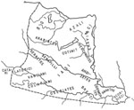
According to Ptolemaios, the Cetius mons was the western border of Pannonia, which can be identified with the ranges of the Styrian Alps, the Rax and the Schneeberg. In the NW, at the Danube, pannonian troops were stationed in Klosterneuburg; and from the basin of Vienna inscriptions of decurios, from Carnuntum, Scarbantia and Savaria, are known. The frontier, along the Mura River, could be equal to the present border of Austria and Slovenia. Along the Drava, west from Poetovio, the border is unsure. It is known that Celeia was attached to Noricum, and the border could be extended to eastward from the city, to the reach of the Sava. In the region south from the river, the territory of Neviodunum, in the western part of which there was the Praetorium Latobicorum situated, was still attached to Pannonia. The southern frontier, in the direction of Dalmatia, is really problematic. It can be positioned somewhere to south from Neviodunum and at the region of the Kulpa’s (Colapis) source in the direction of NW-SE, under the reach of the Sava. The border station of Ad Fines, 21 miles away from Siscia, indicates the closeness of the frontier. A reach of the Sava was the common border of Moesia Superior and Pannonia Inferior. The change of the frontier, in the time of Domitianus, when Syrmia was temporarily annexed by Moesia Superior, is not clearly accepted among the researchers.
The Danube was the northern and eastern border.
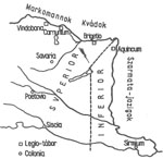 In 106 AD. Pannonia was divided by Trajan into two parts: Pannonia Superior
was the western part, Pannonia Inferior was the eastern part of the province.
The border between the parts ran NE and SW, then N and S. We can take Ptolemaios’
arrangement of Pannonia’s tribes as per the provinces for these basis. On the
basis of these, the border ran on the ridges of the Pilis and the Vértes,
from Aquincum and the land of the eravisci to the NE-tip of the Lake
Balaton. It is shown by the military diplomas and milestones found in the domains.
We haven’t got proofs from the region south from the Lake Balaton. On the strength
of a data from 333 AD., the border could be crossed at Mariniana, 70 km from
Mursa. The frontier could be positioned along the Bosna (Bathinus) river, between
the land of the Oseriates and the Breuci (see the map).
In 106 AD. Pannonia was divided by Trajan into two parts: Pannonia Superior
was the western part, Pannonia Inferior was the eastern part of the province.
The border between the parts ran NE and SW, then N and S. We can take Ptolemaios’
arrangement of Pannonia’s tribes as per the provinces for these basis. On the
basis of these, the border ran on the ridges of the Pilis and the Vértes,
from Aquincum and the land of the eravisci to the NE-tip of the Lake
Balaton. It is shown by the military diplomas and milestones found in the domains.
We haven’t got proofs from the region south from the Lake Balaton. On the strength
of a data from 333 AD., the border could be crossed at Mariniana, 70 km from
Mursa. The frontier could be positioned along the Bosna (Bathinus) river, between
the land of the Oseriates and the Breuci (see the map).
 In 214 AD., in the time of Caracalla’s modification of the borders, the
territory of Brigetio and the municipium of Mogentiana were incorporated by
Pannonia Inferior. On the basis of several inscriptions the new frontier started
from the Danube, to east from Arrabona, and ran into the direction of the western
corner of the Lake Balaton. South from the Drava, the border didn’t change.
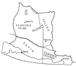
The domains were divided into two parts, in the times of the tetrarchy. The
northern part of Pannonia Superior was Pannonia Prima, its southern part was
Savia; the northern part of Pannonia Inferior was Valeria, its southern part
was Pannonia Secunda.The line of the halving can be searched along the Drava
or to north from it, because the territory of several municipium (Mursa, Municipium
Iasorum) extended over the northern side of the river as well (see the map).
In 214 AD., in the time of Caracalla’s modification of the borders, the
territory of Brigetio and the municipium of Mogentiana were incorporated by
Pannonia Inferior. On the basis of several inscriptions the new frontier started
from the Danube, to east from Arrabona, and ran into the direction of the western
corner of the Lake Balaton. South from the Drava, the border didn’t change.
The domains were divided into two parts, in the times of the tetrarchy. The
northern part of Pannonia Superior was Pannonia Prima, its southern part was
Savia; the northern part of Pannonia Inferior was Valeria, its southern part
was Pannonia Secunda.The line of the halving can be searched along the Drava
or to north from it, because the territory of several municipium (Mursa, Municipium
Iasorum) extended over the northern side of the river as well (see the map).
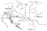 In the time of the roman conquest, Celtic tribes lived in the Carpathian
Basin, which was occupied by them from the end of the 5th century
BC., during the 4th-3d century BC. Their names are not known. On
the basis of the written inscriptions (Strabon VII, 2-3) referring to the migration
of the Cimberians (114-113 BC.), it can be summarized that the Carpathian Basin
was divided by three Celtic tribes in the end of the 2nd century
BC.: on the north the boii, on SW the taurisci, on SE the scordisci.
This situation existed until the second quarter of the 1st century BC., when
the scordisci (80 BC.) and the boii (60-50 BC.) retreated back
to smaller territory (see below).
In the time of the roman conquest, Celtic tribes lived in the Carpathian
Basin, which was occupied by them from the end of the 5th century
BC., during the 4th-3d century BC. Their names are not known. On
the basis of the written inscriptions (Strabon VII, 2-3) referring to the migration
of the Cimberians (114-113 BC.), it can be summarized that the Carpathian Basin
was divided by three Celtic tribes in the end of the 2nd century
BC.: on the north the boii, on SW the taurisci, on SE the scordisci.
This situation existed until the second quarter of the 1st century BC., when
the scordisci (80 BC.) and the boii (60-50 BC.) retreated back
to smaller territory (see below).
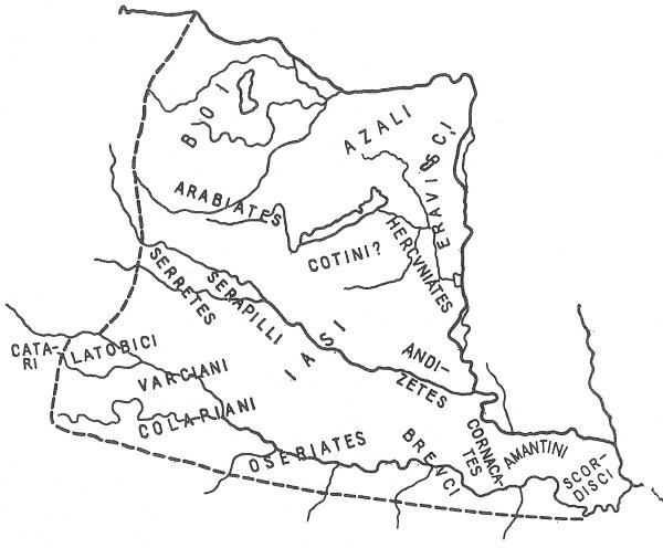
 The tribes, living in the territory of Pannonia, were organized into
civitas peregrinas, after Pannonia’s conquest, nor later than the Pannonian
tribes’ rebellion (about 10 AD.). Some name of the civitas pergrinas
with roman origin shows, that they were artifically established by the romans
and they weren’t original units of tribes.The names of tribes living there,
can be identified by the names of the civitates written by Pliny (NH III, 48)
and Ptolemaios. The gravestones and military diplomas provide more information
about the location of civitates.
The tribes, living in the territory of Pannonia, were organized into
civitas peregrinas, after Pannonia’s conquest, nor later than the Pannonian
tribes’ rebellion (about 10 AD.). Some name of the civitas pergrinas
with roman origin shows, that they were artifically established by the romans
and they weren’t original units of tribes.The names of tribes living there,
can be identified by the names of the civitates written by Pliny (NH III, 48)
and Ptolemaios. The gravestones and military diplomas provide more information
about the location of civitates.
Along the Sava
Along the Drava
Along the Danube
- Boii: in 191 BC., from Italy expelled boius tribe migrated to the Danube (Strabon V,1,6,) and they established their zone of power on the NW-part of the Carpathian basin, which meant loose alliance of different Celtic tribes and ethnic groups. This alliance was ceased by the Dacians’ conquest between 60-50 BC. After that, they situated in the region of the Lajta, to west from the Amber Road, between the Danube and Savaria. After the foundation of Savaria and Scarbantia, they retreated back to west and north from the Lake Fertő.
- Eravisci: the territory of the civitas Eraviscorum stretched from the Danube bend to the northern part of the Hegyhát, it was separated from the civitas Azaliorum by the ranges of the Pilis and Vértes. According to the viewpoint of the up-to-date researches, it can be imagined that the eravisci arrived in the territory of the latter Pannonia together with the boii, and they took possession of the Danube bend in the course of the development of the boius’ sphere of power.According to others, they crossed the Danube from its opposite side to the NE-Pannonia after the victory of the Dacians.
On the basis of the inscriptions, the tribes of the Carni and the Decentii are also known, but their location is uncertain.
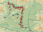
After the roman conquest, in the time of the Iulian-Claudian dynasty, the army was mostly placed to the interior parts of the province, where they had to control the native centres and cover the line of the army’s deployment leading to the Danube and the reserves as well. In the vicinity of Emona, an auxiliary-camp (Nadleški Hrib) is known of that early time. On the basis of the written sources, the territory of the scordisci was protected by smaller garrison troops. Along the Amber Road, leading to Carnuntum, in the vicinity of Zalalövő, a military camp from the time of Tiberius-Claudius was uncovered, which was used to the end of the 1st century AD. Wooden houses, referring to an earlier camp, are also known from the region of Aquae Iasae.
We have only a few datas about the legio-camps in the 1st century AD. After the repression of the Pannonian-Dalmatian rebellion, the earliest legio-camp was in Poetovio established, where the unit was stationed till the end of the 1st century AD. In the wider vicinity of Emona, a unit could be surely stationed, however its location is not known precisely. Further camps from the earlier period are supposed to be in Siscia and in Mursa. In Carnuntum a palisade-likely fort, from the time of Claudius was found, in Aquincum the place and the external defences of the camp, from the time of Domitian are known.
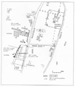
Before the Flavian-period, garrison troops were stationed only at the end of roads, connecting Italy radial with the Danube. In Gorsium, along the diagonal road leading from Poetovio to Aquincum, a camp with earthwork, from the Claudian-period is known, which was given up in the beginning of the 2nd century AD. The permanent legio-camp in Carnuntum was built in the end of the reign of Tiberius or the beginning of the reign of Claudius, not much later could have been the occupation of Arrabona, which situated with strategical importance. The first equestrian unit was stationed in Aquincum at the same time, and its camp was built south from the later legio-camp. (Pic.I.3.1.) In Brigetio, the first equestrian unit was stationed in the middle of the 1st century AD., and the earlier palisade-camp was found east from the legio-camp. The camp of Albertfalva could be built in the time of Vespasian.
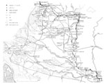
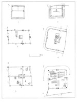
The forts of the limes, settled in the time of the Flavians, were not coincide with the places of the earlier camps in several cases. Periods, from the Flavian-period are known in Klosterneuburg, Vindobona, in Petronell next to Carnuntum, Solva, Cirpi, in Aquincum between the legio-camp and the earlier ala-camp, in Albertfalva, Campona, Vetus Salina, in Intercisa south from the latter camp. The building of the camp-range of the limes along the Danube was ended by the time of Trajan, and after that, their places were not much changed. The camp of Quadrata, Ad Statuas, Azaum, Ulcisia Castra, Matrica and Vetus Salina were built at the same time. The building of the camps along the limes, started in the time of Vespasian and was ended by the time of Hadrian. Camps, built after the time of Hadrian, are not known. Further camps along the limes of the Danube, were built only in the Late-Roman age.
The camps, built both in the Flavian-period and in the time of Trajan, were palisade-constructioned, with poles and causeway fastened by wood-timbers, with one or two moats in front of them. The most part of the interior buildings could have been wooden-huts with sleeper beams. These camps were usually smaller than the latter camps of stone, the walls of which were laid into the fossa of the palisade-camp.
 The camps along the Danube, from the 1st and 2nd
century AD. were built from stone, and the wooden-grounded camp of Carnuntum
was built into stone at the same time. The legio-camp of Brigetio could have
been built between 97-101 AD. The building excavated on the Danube-bank, could
have been attached to the port of the classis Flavia Pannonica. The earlier
palisade-constructioned legio-camp of Aquincum, from the Domitian-Trajan-period
was located at the Danube-bank. The second camp of stone, to south from the
earlier camp was built in the time of Trajan and Hadrian, and it was in use
till the 3rd century AD.
The camps along the Danube, from the 1st and 2nd
century AD. were built from stone, and the wooden-grounded camp of Carnuntum
was built into stone at the same time. The legio-camp of Brigetio could have
been built between 97-101 AD. The building excavated on the Danube-bank, could
have been attached to the port of the classis Flavia Pannonica. The earlier
palisade-constructioned legio-camp of Aquincum, from the Domitian-Trajan-period
was located at the Danube-bank. The second camp of stone, to south from the
earlier camp was built in the time of Trajan and Hadrian, and it was in use
till the 3rd century AD.
The palisade-camps of auxiliary forces, stationed along the limes were built step-by-step. The camp of Solva, Ulcisia Castra, Albertfalva and Campona were built into stone in the beginning of the 2nd century AD. The most part of the camps was rebuilt in the Antonin-period, as the palisade-camp of Azaum, Vetus Salina, Quadrata, Ad Statuas and Intercisa. The destruction of the Marcomannian-wars made the rebuilding and repairing imperative, and a part of the camps were built into stone at the same time. To the end of the 2nd century AD., stone-camps were situated along the limes of the Danube (see the map).
|
|
|
Solva, Ulcisia Castra,
Albertfalva
|
Campona
|
Azaum, Vetus Salina,
Quadrata, Ad Statuas and Intercisa
|
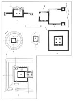
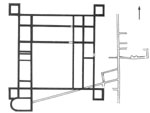
 The quadrate-, rectangle- or parallelogram-shaped camps with rounded corners
and interior corner turrets, come into being in the Hadrian-Antonines period
were significant to the Late-Roman times, and only in that time were they rebuilt.
A newer fort-type appeared in the time of Diocletian, which was built on high
ground to its harder approach; their ground plans accommodated to the circumstances
of the terrain, and only one gate was generally built. The earliest fort of
the tetrachy, the camp of Castra ad Herculem was built between 294-297 AD.,
at the Danube bend. The buildings of fan-shaped corner turrets to the rounded
corners of the forts from the 2nd century AD., are characteristic of the time
of I.Constantinus. Fan-shaped corner turrets are known from Quadrata, Ad Statuas,
Azaum, Crumerum, Ulcisia Castra, Campona, Intercisa and Altinum. The corner
turret of the forts, built at the same time, was built together with the walls,
e.g. in Visegrád (Pone Navata), where beside these; seven horseshoe shaped
towers were built on the sides. Horseshoe shaped towers, similar to the camp
of Visegrád, from the time of I. Constantin are also known from Klosterneuburg,
Arrabona, Castra ad Herculem and Ulcisia Castra (Castra Constantia). In Aquincum,
to SW from the earlier castrum, a port-fortress was established in the
time of Diocletian or I. Constantin.
The quadrate-, rectangle- or parallelogram-shaped camps with rounded corners
and interior corner turrets, come into being in the Hadrian-Antonines period
were significant to the Late-Roman times, and only in that time were they rebuilt.
A newer fort-type appeared in the time of Diocletian, which was built on high
ground to its harder approach; their ground plans accommodated to the circumstances
of the terrain, and only one gate was generally built. The earliest fort of
the tetrachy, the camp of Castra ad Herculem was built between 294-297 AD.,
at the Danube bend. The buildings of fan-shaped corner turrets to the rounded
corners of the forts from the 2nd century AD., are characteristic of the time
of I.Constantinus. Fan-shaped corner turrets are known from Quadrata, Ad Statuas,
Azaum, Crumerum, Ulcisia Castra, Campona, Intercisa and Altinum. The corner
turret of the forts, built at the same time, was built together with the walls,
e.g. in Visegrád (Pone Navata), where beside these; seven horseshoe shaped
towers were built on the sides. Horseshoe shaped towers, similar to the camp
of Visegrád, from the time of I. Constantin are also known from Klosterneuburg,
Arrabona, Castra ad Herculem and Ulcisia Castra (Castra Constantia). In Aquincum,
to SW from the earlier castrum, a port-fortress was established in the
time of Diocletian or I. Constantin.
 In the time of I. Valentinian, mainly minor fortresses and watchtowers
were built in large number, at the points thought to be dangerous. New forts
were established as the fort of Esztergom and Tokod. After the time of I. Valentinian,
systematic buildings of the forts were not revealing; mostly the territory of
the earlier camps was decreased. The distances between the watchtowers, located
along the limes, was different on some section, and the distance changed between
0.9 and 6 km, which can be explained by the circumstances of the terrain and
the visibility. The system of the watchtowers is not really known in the time
extended to the end of the 3d century AD. The earlier watchtowers, established
in the 1st and 2nd century AD., were built from wood and with moats, similar
to the camps. Most part of the watchtowers, known today, was built in the time
of I. Valentinian. They were circular and quadrate-shaped with one or two moats.
In the time of I. Valentinian, mainly minor fortresses and watchtowers
were built in large number, at the points thought to be dangerous. New forts
were established as the fort of Esztergom and Tokod. After the time of I. Valentinian,
systematic buildings of the forts were not revealing; mostly the territory of
the earlier camps was decreased. The distances between the watchtowers, located
along the limes, was different on some section, and the distance changed between
0.9 and 6 km, which can be explained by the circumstances of the terrain and
the visibility. The system of the watchtowers is not really known in the time
extended to the end of the 3d century AD. The earlier watchtowers, established
in the 1st and 2nd century AD., were built from wood and with moats, similar
to the camps. Most part of the watchtowers, known today, was built in the time
of I. Valentinian. They were circular and quadrate-shaped with one or two moats.
On the basis of the inscriptions, the existence of beneficiarius-stations can be proved, which controlled the order of the province’s interior region. However, buildings, related to these, are not known for the moment.
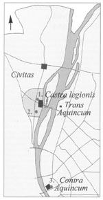
 The forts of the left riverbank had a significant role in controlling the
crossing-places. In these forts, auxiliary forces were stationed. Iža-Leányvár,
from the Early-Imperial period, located opposite to Brigetio, on the left riverbank
is known. Smaller buildings with uncertain ground plan are known from the opposite
side of Pozsony, Zebegény, Lussonium and Lugio from the 1st-3d century
AD. Along the Pannonian limes, six forts of trans- or contra anterior
constituent are mentioned by the Notitia Dignitatum referring to the location
at the opposite side of the Danube. The number of the Late-Roman opposing-forts
is quite larger than this. The camp, opposite to the legio-camp of Aquincum,
was built not much later than the reign of Marcus Aurelius, and it can be identified
with Transaquincum, which covered the defence of the left bank of the Danube-bridge.
The thick-walled, Late-Roman fortress, which was excavated in the city centre
of Budapest, is known as Contra Aquincum.
The forts of the left riverbank had a significant role in controlling the
crossing-places. In these forts, auxiliary forces were stationed. Iža-Leányvár,
from the Early-Imperial period, located opposite to Brigetio, on the left riverbank
is known. Smaller buildings with uncertain ground plan are known from the opposite
side of Pozsony, Zebegény, Lussonium and Lugio from the 1st-3d century
AD. Along the Pannonian limes, six forts of trans- or contra anterior
constituent are mentioned by the Notitia Dignitatum referring to the location
at the opposite side of the Danube. The number of the Late-Roman opposing-forts
is quite larger than this. The camp, opposite to the legio-camp of Aquincum,
was built not much later than the reign of Marcus Aurelius, and it can be identified
with Transaquincum, which covered the defence of the left bank of the Danube-bridge.
The thick-walled, Late-Roman fortress, which was excavated in the city centre
of Budapest, is known as Contra Aquincum.
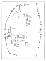
|
|
Transaquincum
|
Contra Aquincum
|
A
fort-type, frequent in the province of Valeria and built at the riverbank, is
mentioned by the Notitia Dignitatum as a burgus, which is called Nógrádverőce-type.
The forts, closed by its three sides, consisted of a big tower, two smaller
quadrate corner towers and walls running down to the Danube. They functioned
as ports and loading-places. This type of forts was at further places uncovered,
opposite to each others on the left and right river-bank of the Danube, so they
could have been crossing-places of the transport to the Barbaricum from the
end of the 3rd century AD. The roman forces were stationed to the end of the
4th century AD. in these forts.
 The existence of the Pannonian cities can be generally proved by those
inscriptions, on which the place is mentioned as a municipium or as a
colonia. In case of Pannonia, we cannot rely on the written sources (the
place-names’ lists of Pliny and Ptolemaios). In the case of several cities,
the time of the foundation is uncertain for the moment, it can be proved only
by the imperial attribute or the tribus and pseudotribus of the
city.
The existence of the Pannonian cities can be generally proved by those
inscriptions, on which the place is mentioned as a municipium or as a
colonia. In case of Pannonia, we cannot rely on the written sources (the
place-names’ lists of Pliny and Ptolemaios). In the case of several cities,
the time of the foundation is uncertain for the moment, it can be proved only
by the imperial attribute or the tribus and pseudotribus of the
city.
 The earliest city in the territory of Pannonia, established in the Iulius-Claudius
period, was Colonia Claudia Savaria. Savaria was established by the settlement
of the Italian veterans of the legio XV Apollinaris, halfway between
the legio-camp of Poetovio and Carnuntum. The territory of Savaria was surely
attached to Noricum before the time of Claudius, but according to several researchers,
the city was established in the territory of Noricum, and not in the territory
of Pannonia. One part of the settled veterans returned to their previous station,
and settled down next to Carnuntum, in the expectation of enrichment. Among
the civic inhabitants, settled in Savaria, families of merchants from Aquileila
can be proved, who took part in the direction of the city as well; and people
removed from Emona.
The earliest city in the territory of Pannonia, established in the Iulius-Claudius
period, was Colonia Claudia Savaria. Savaria was established by the settlement
of the Italian veterans of the legio XV Apollinaris, halfway between
the legio-camp of Poetovio and Carnuntum. The territory of Savaria was surely
attached to Noricum before the time of Claudius, but according to several researchers,
the city was established in the territory of Noricum, and not in the territory
of Pannonia. One part of the settled veterans returned to their previous station,
and settled down next to Carnuntum, in the expectation of enrichment. Among
the civic inhabitants, settled in Savaria, families of merchants from Aquileila
can be proved, who took part in the direction of the city as well; and people
removed from Emona.
Both municipiums – Andautonia, Neviodunum, Scarbantia – and colonias – Sirmium, Siscia – were established in the time of the Flavians. From the two colonias is known that, they were founded by deductio of the naval force’s soldiers in the time of Vespasian. Siscia had undoubtedly a predecessor-city, called Segestiké. Scarbantia existed already in the time of Tiberius, it is mentioned by Pliny as oppidum Scarbantia Iulia. In this case, only the legal status of the city changed significant, the inhabitants were not probably influenced by the transformation into municipium. The Flavian municipiums and colonias were founded promoting and controlling the trade along the Sava and the Amber Road. During the 2nd century AD., when the limes along the Danube was extended, these road lost their importance, and cities along them were not any more established, however some settlement (e.g. Salla) got the status of municipium.
Colonia Ulpia Traiana Poetovio was founded by Trajan from the veterans of the legio I and II adiutrix and maybe from the legio IIII Flavia with repeated settling. Poetovio was a legio-camp in the 1st century AD., and it was given up before the deductio of the colonia.
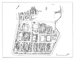
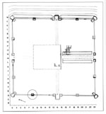
Most cities were founded in the time of the Antonines: Municipium aelium Aquincum, Bassiana, Carnuntum, Cibalae, Halicanum, Mogentiana, Municipium Iasorum (Aquae Balisae) and Salla. The only one colonia from the Antonin period was Mursa, established by Hadrian. It can not be surely proved that, it was established by deductio of the veterans, because veterans are not known from here. Mursa was probably the latest colonia, which was established as a new city. After that the status of colonia was given only to municipiums: Aquincum and Carnuntum became a colonia in 194 AD.; Bassiana and Cibalae got the status not much later than the time of Caracalla.
|
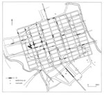
|
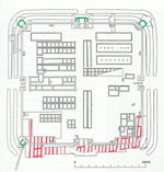
Municipium aelium Aquincum
|
Bassiana
|
On the basis of its name, Brigetio (municipium Antoniniana) was founded by Caracalla, but it is supposed that the status of municipium was already given by Septimius Severus. It could have become a colonia in the second part of the 3rd century. Vindobona is mentioned by an inscription, from the 3rd century AD. as a municipium. The municipium status of Sopianae and Gorsium can not to be undoubtedly proved for the moment. On the basis of the location of the cities, founded in the 2nd century AD., and of the latter municipiums and colonies, it can be stated that, the importance of the roads along the Drava and the Danube increased at the same time ( this the time when the four legio were settled at the Danube) and cities were founded at the interior parts of the province. However, the cities spread unevenly in the territory of the province. Unknown settlements are prospective from the regions, destitute of inscriptions, and the municipium Faustinianorum, mun. Volg […] and mun. Spodent […] have to be identified.
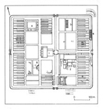
 The building of the roads in Pannonia – in the territory of the present
Slovenia - started in the time of Augustus. The first road leaded to Siscia
from Aquileia, through Nauportus and Emona. Salona was the another starting
point of the roads leading to Pannonia. The Amber Road, leading to north from
Emona, was established in the time of Augustus-Tiberius, which protected the
connection of Carnuntum’s legio-camp with the southern regions. The road, connecting
Sirmium and Emona along the Sava was built in the earliest time of the conquest.
In the first time, these roads were simply trails, later came after its building
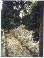
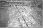
and paving, resp. bridges and milestones were established. The limes-road was
started to pave with stone in the 2nd century AD. The width of the roads was
not unified, it fluctuated between 5.5-12 m. The face of the roads was strewn
with gravel, and its foundation was 70-90 cm deep. Road-ditches, with plastered
slope are known from Carnuntum and Vindobona. Road-faces, covered with traprocks,
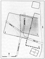
survived in good condition in Savaria, Aquincum and Zalalövő.
The building of the roads in Pannonia – in the territory of the present
Slovenia - started in the time of Augustus. The first road leaded to Siscia
from Aquileia, through Nauportus and Emona. Salona was the another starting
point of the roads leading to Pannonia. The Amber Road, leading to north from
Emona, was established in the time of Augustus-Tiberius, which protected the
connection of Carnuntum’s legio-camp with the southern regions. The road, connecting
Sirmium and Emona along the Sava was built in the earliest time of the conquest.
In the first time, these roads were simply trails, later came after its building
and paving, resp. bridges and milestones were established. The limes-road was
started to pave with stone in the 2nd century AD. The width of the roads was
not unified, it fluctuated between 5.5-12 m. The face of the roads was strewn
with gravel, and its foundation was 70-90 cm deep. Road-ditches, with plastered
slope are known from Carnuntum and Vindobona. Road-faces, covered with traprocks,
survived in good condition in Savaria, Aquincum and Zalalövő.
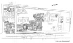
|
|
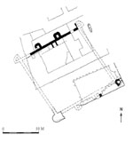
Savaria
|
Aquincum
|
 About the Pannonian road-stations are not much known, e.g. in the vicinity
of the Scarbantia-Carnuntum road, at Purbach and along the road of Sopianae-Savaria,
at Sümeg, road-stations (cursus publicus) were excavated.
About the Pannonian road-stations are not much known, e.g. in the vicinity
of the Scarbantia-Carnuntum road, at Purbach and along the road of Sopianae-Savaria,
at Sümeg, road-stations (cursus publicus) were excavated.
Remains of bridges came into light in the Sava, at Sirmium, in the Drava, at Poetovio and in the Danube, at Aquincum. The legio-camp of Aquincum was connected with the opposing-fort (Transaquincum), situated on the opposite side of the Danube, by a bridge.
In the vicinity of Savaria, the first milestone was set up by Nerva; the second
one was set up by Trajan. The placing of the milestones along the sections of
the limes-road, between Vindobona-Carnuntum-Brigetio, Vindobona-Scarbantia and
Emona-Neviodunum-Siscia, started in the beginning of the reign of Antoninus
Pius, between 139-143 AD. It can be stated that there aren’t any milestones
along the interior, diagonal-roads, except for the road between Aquincum and
Brigetio, and they are infrequent along the Amber Road and the Drava as well.
Milestones were generally positioned on the limes-road, from the time of the
Severans. The milestones were mostly counted from the legio-camps (a Vindobona,
a Carnunto, a Brigetione, ab Aquinco) or from the cities. The two counting,
started from different direction, were met at the borders of the territories.
This kind of counting was in use in the southern and SW part of the province
and along the Amber Road. The opinions about the reason of their foundation
differ among the researchers. Some people say that the milestones were
 concerned the building and the repairing of the roads, according to others
they were positioned because of propagandistic reasons. Contrasted with this
opinion, it is supposed that, the annual repairing of the roads was marked by
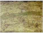
milestones only if they could use them for propagandistic reasons. The most
important sources, respecting of the road-lines, are the Itinerarium Antoniniana
and the Tabula Peutingeria. 16 stations of the Pannonian roads are mentioned
by the Itin. Ant., the limes-road, the Amber Road, the roads along the Drava
and the Sava, the road between Mursa and Cibalae were indicated by the Tab.
Peut. On the basis of the Itin. Ant., the most significant ways in the 3d-4th
century AD., leaded to Italy and to the western provinces from the north. In
this time the Amber Road lost from its importance. The section of the Amber
Road between Poetovio and Savaria, divided the first time after Salla, then
from Scarbantia the road was bisected: it leaded to the Baltic Sea through Carnuntum,
and to Vindobona, from where it continued as the limes-road. In the Carnuntum-Vindobona-Scarbantia
triangle, several roads with local importance are known.
concerned the building and the repairing of the roads, according to others
they were positioned because of propagandistic reasons. Contrasted with this
opinion, it is supposed that, the annual repairing of the roads was marked by
milestones only if they could use them for propagandistic reasons. The most
important sources, respecting of the road-lines, are the Itinerarium Antoniniana
and the Tabula Peutingeria. 16 stations of the Pannonian roads are mentioned
by the Itin. Ant., the limes-road, the Amber Road, the roads along the Drava
and the Sava, the road between Mursa and Cibalae were indicated by the Tab.
Peut. On the basis of the Itin. Ant., the most significant ways in the 3d-4th
century AD., leaded to Italy and to the western provinces from the north. In
this time the Amber Road lost from its importance. The section of the Amber
Road between Poetovio and Savaria, divided the first time after Salla, then
from Scarbantia the road was bisected: it leaded to the Baltic Sea through Carnuntum,
and to Vindobona, from where it continued as the limes-road. In the Carnuntum-Vindobona-Scarbantia
triangle, several roads with local importance are known.
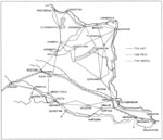
The road along the Drava was mentioned by the sources of the 3d-4th century AD. as a significant road, because the traffic between Italy and the East-Balkan was arranged on it, and it had an importance when military operations were executed. The road was branched off from the Amber Road after Poetovio, and ran to Mursa, along the southern bank of the Drava. Then it turned to south, ran to Cibalae, but not along the river any more, from Cibalae it led to Sirmium, in the direction of SE, where it crossed the road, running along the Sava. From Sirmium it was leaded to the border of the province, through Bassiana, then it was bisected and two roads led to Singidunum.
Emona was the starting point of the road, running along the Sava, however it was not leaded along the river-bank to Neviodunum and Siscia, but to south from that. Siscia, on the road of the Sava, was a significant centre of the traffic and the trade. A road, leading to north, was connected with Poetovio, and by means of it, with the Amber Road. Two roads led to the north from Siscia: one of it ran to Sirmium, along the southern riverside of the Sava, through Servitium; at Sirmium it joined the road of the Drava’s bank. A road was branched off at Servitium, which was connected with Salona, through Dalmatia. The other road, which leaded to the north, crossed the region between the two rivers, in the direction of W-E, and ran to Mursa and Cibelae, through Aquae Balisae. The road along the Sava is mentioned by the Itin. Ant. as a road with local importance. The road, running along the Danube, which connected the limes-camps, is also mentioned by the Itin. Ant. and the Tab. Peut., some sections of its line differ from each other in the two sources. The sections of it are known on the one hand by the excavations, on the other hand by the air photos, from which is known that, its line was many times modified (e.g. in the region of Intercisa after 260 AD.). Derived from its military character, beside the road-stations, watchtowers were established along the both sides of the road, in regular distance from each other. In the Tab. Peut., the road, leading to the Danube bend was cut along the Danube by a diagonal road, running between Aquincum and Brigetio. The Danube bend of Pozsony was also cut by the limes-road between Gerulata and Carnuntum. The Pannonian section of the limes-road ran to Klosterneuburg, through Vindobona on the west; on the south it ran to Singidunum. Savaria, Arrabona, Brigetio, Aquincum, Antinae, Mursa and Sopianae were the starting points of the diagonal roads, running between the Drava and the Danube. Poetovio was connected with Aquincum by a road, running along the southern bank of the Lake Balaton. It is supposed that a road could run along the northern bank of the Lake Balaton, and it could have joined the road of Savaria-Aquincum in the vicinity of Veszprém. From Savaria a road, apart from Aquincum, led to Arrabona as well.
Sopianae (the administrative centre of Valeria province) was a significant centre of traffic; on the basis of the Itin. Ant. it was crossed by two imperial roads of deployment. Both roads – on the same traces - were branched off from the limes-road at Antiana, and were bisected in Sopianae. According to the Itin. Ant., the road from Sirmium to Treviri, which connected the two big imperial residences, went along the Savaria line, and to Carnuntum along the Sopianae-Arrabona line, which continued in the limes after Arrabona. Apart from these, it also mentions a Sopianae-Brigetio and a Sopianae-Aquincum road. These two roads presumably met somewhere near the Velence-road, and then continued bisected.
Besides the busy roads mentioned above, smaller roads also connected Pannonia with the neighbouring provinces. Towards Dalmatia a road led from Siscia through Senia to Aquileia, resp. the already mentioned road from Sirium through Servitium to Salona. Towards Noricum, a road is supposed to led in the valley of the Drava River.
Towards the barbarian territories the most important roads originated from Carnuntum and Aquincum. The Amber Road crossed the Danube at Carnuntum, and it ran toward the north in the marcommannian territory on the rights side of the Morva river. A road from Carnuntum also ran on the left bank of the Morva river. A road ran in almost every valley from Pannonia to the territory of the Quadi: from Celamantia, in the valley of Nyitra; to opposite to Solva, along the Garam; and from Verőce, in the valley of the Ipoly. From Transaquincum, resp. from Contra Aquincum along the left river-side of the Danube ran the road to the territory of the Sarmatians. This later led to Porolissum in Dacia on the Szolnok-Debrecen road. A customs' station functioned in Porolissum. A road led from Intercisa to Bologna through the territory of the Sarmatians. The road from Lugio going to Micia via Szeged also connected Dacia with the southern part of the province. A road led from Aquincum as well to Micia in Dacia, where a frontier -and customs' station functioned. The area of Szeged was an important commercial centre, which was not only connected with Dacia but also with the Jazyges. The research is looking for Parthiscum mentioned by Ptolemaios in this territory.
Besides the continental roads, water-ways were also of great importnace in Pannonia. The most significant traffic was on the Sava, Drava and Danube. The Greeks of the Archaic-period also known of the good shipping opportunities on the Sava; it is mentioned in the stories of the Argo. When writing about the South Pannonian transport, Strabón mentiones the shipping on the Sava, Kulpa and Drava. The worship of the river gods refers to lively traffic on the Sava. On the Sava, a ship fleet also stationed in the early times. The Danube as a waterway became important after the early occupation of the riverbank in the middle of the 1st century AD. After the building up of the settlements along the river, the import goods from the western provinces of the empire arrived in Pannonia on the Danube. Commercial harbours were excavated in Carnuntum and Vindobona.
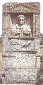 Regarding the transport vehicles, we only know that the use of the wagons
was spread among the aboriginals well before the Roman conquest. This is indicated
by the wagon burials in the end of 1st -beginning of 2nd
century, and also by those tombstones in which the dead travels to the other
world. These were made after the Roman-model but depicted the own imaginations
of the aboriginals. They usually harnessed horses but we know tombstones with
oxen or mule as well. After the conquest, the post service was organized in
Pannonia as well. A source from the 2nd century mentioned veredarii
Pannonici, which refers to service of dispatch-rider.
Regarding the transport vehicles, we only know that the use of the wagons
was spread among the aboriginals well before the Roman conquest. This is indicated
by the wagon burials in the end of 1st -beginning of 2nd
century, and also by those tombstones in which the dead travels to the other
world. These were made after the Roman-model but depicted the own imaginations
of the aboriginals. They usually harnessed horses but we know tombstones with
oxen or mule as well. After the conquest, the post service was organized in
Pannonia as well. A source from the 2nd century mentioned veredarii
Pannonici, which refers to service of dispatch-rider.
We know on the basis of inscriptions and a tombstone picture that the ships of the classis Pannonica were boats for three oarsmen (triremes).
Alföldy 1960 = Alföldy G., Pannoniciani augures. Antik Tanulmányok 7 (1960).
Bodó 2003 = Bodó S. (Hrsg.), Forschungen in Aqincum 1969-2002. Aquincum Nostrum II.2. 2003. Budapest 2003.
Aquincum 1995 = Istenek, katonák, polgárok Aquincumban. Kiállítás az Aquincumi Múzeum megnyitásának 100. évfordulója alkalmából Budapest 1995.
Kovács 1999 = Kovács P., Civitas Eraviscorum. Antaeus 24(1999) 278-295.
Mócsy 1962 = Mócsy A., Pannonia. In: PWRE IX. Stuttgart 1962, 515-776.
Mócsy 1974 = Mócsy A., Pannonia and Upper Moesia. A History of the Middle Danube Provinces of the Roman Empire. London – Boston 1974.
Mócsy 1975a = Mócsy A., Pannonia a korai császárság idején. Budapest 1975.
Mócsy 1975b = Mócsy A., Pannonia a késői császárkorban. Budapest 1975.
Mócsy-Fitz 1990 = Mócsy A./ Fitz J. (szerk.), Pannonia régészeti kézikönyve. Budapest 1990.
Aquincum 2000 = Ókeresztény emlékek Aquincumban. A BTM Aquincumi Múzeumának kamara kiállítása a Millenium alklamából. Budapest 2000.
Póczy 1999 = Póczy K., Iuppiter Optimus Maximus Teutanus Aquincumban. In: Gaál A. (szerk.), Pannoniai kutatások. A Soproni Sándor Emlékkonferencia előadásai (Bölcske, 1998. október 7.). Szekszárd 1999, 201-223.
RCP 1998 = Religions and Cults in Pannonia. A Szent István Király Múzeum Közleményei. Ser. A. No. 33. Székesfehérvár 1998.
Soproni 1990 = Soproni S., Előzetes jelentés a bölcskei késő római ellenerőd kutatásáról. Communicationes Archaeologicae Hungariae 1990, 133-140.
Zsidi 2002 = Zsidi P., Aquincum polgárvárosa. Budapest 2002.
Zsidi 2003 = Zsidi P./ Magyar M., Fürdőépület az aquincumi polgárváros déli városfalán kívül. Aquincumi Füzetek 9 (2003) 69-85.