See this text in ![]()
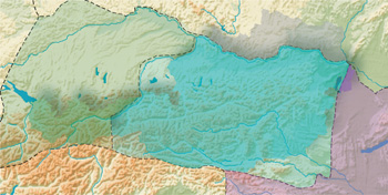 Austria extends over parts of three former Roman provinces. To Raetia and
Vindelicia belonged the present state of Vorarlberg, the settlement zone of
the Celtic Brigantii, as did western Tyrol where the Breuni lived. The border
between Raetia and the Celtic regnum Noricum, which after ca. A.D. 50 became
the Roman province of Noricum, ran from the mouth of the river Inn near Passau
upstream as far as Kufstein and then to the south, whereby the Southern Tyrolean
Pustertal still belonged to Noricum. The Bavarian Chiem region, and the other
areas enclosed by the Saalach and Inn, belonged to Noricum, and in addition
probably also a narrow strip to the west of the river Inn. The southern border
of Noricum corresponded roughly to the current frontier between Austria and
Italy. In the south-east, the regions around Celje (Roman: Celeia) and Maribor
(formerly part of south Styria, now Slovenian) also belonged to Noricum. The
eastern frontier between Noricum and the province of Pannonia (after A.D. 106
Pannonia Superior = Upper Pannonia) ran through the sloping foothills of the
eastern Alps, approximately in the region of the present border between Hungary
and Austria up to the ‘Buckligen Welt’ (hilly area). To the north,
the course of the frontier then turned to the west, and ran over the eastern
slopes of the ‘Wienerwald’ (Vienna woods) up to the Danube. Klosterneuburg
would have constituted the westernmost point of Pannonia. The Vienna Basin
and the extensively flat area downstream, down to the region around Wiener
Neustadt, were Pannonian. Here the Celtic Boii settled in pre-Roman times.
Burgenland, Vienna and the current district below the Vienna Woods belonging
to the state of Lower Austria were also part of Pannonia; while the district
above the Vienna Woods, Upper Austria south of the Danube, Salzburg, Carinthia,
East Tyrol and Styria all belonged to Noricum.
Austria extends over parts of three former Roman provinces. To Raetia and
Vindelicia belonged the present state of Vorarlberg, the settlement zone of
the Celtic Brigantii, as did western Tyrol where the Breuni lived. The border
between Raetia and the Celtic regnum Noricum, which after ca. A.D. 50 became
the Roman province of Noricum, ran from the mouth of the river Inn near Passau
upstream as far as Kufstein and then to the south, whereby the Southern Tyrolean
Pustertal still belonged to Noricum. The Bavarian Chiem region, and the other
areas enclosed by the Saalach and Inn, belonged to Noricum, and in addition
probably also a narrow strip to the west of the river Inn. The southern border
of Noricum corresponded roughly to the current frontier between Austria and
Italy. In the south-east, the regions around Celje (Roman: Celeia) and Maribor
(formerly part of south Styria, now Slovenian) also belonged to Noricum. The
eastern frontier between Noricum and the province of Pannonia (after A.D. 106
Pannonia Superior = Upper Pannonia) ran through the sloping foothills of the
eastern Alps, approximately in the region of the present border between Hungary
and Austria up to the ‘Buckligen Welt’ (hilly area). To the north,
the course of the frontier then turned to the west, and ran over the eastern
slopes of the ‘Wienerwald’ (Vienna woods) up to the Danube. Klosterneuburg
would have constituted the westernmost point of Pannonia. The Vienna Basin
and the extensively flat area downstream, down to the region around Wiener
Neustadt, were Pannonian. Here the Celtic Boii settled in pre-Roman times.
Burgenland, Vienna and the current district below the Vienna Woods belonging
to the state of Lower Austria were also part of Pannonia; while the district
above the Vienna Woods, Upper Austria south of the Danube, Salzburg, Carinthia,
East Tyrol and Styria all belonged to Noricum.
Vienna (Vindobona), the modern state capital Bregenz (Brigantium), Linz (Lentia),
Salzburg (Iuvavum), St. Pölten (Cetium) and additional important administrative
centres such as Enns (Lauriacum), Leibnitz (Flavia Solva), Tulln (Comagenis),
Villach (Santicum) and Wels (Ovilavis) all stand geographically, and in part
also functionally, in direct succession to Roman towns or military camps.
All Austrian regions today north of the Danube lay beyond the Roman Empire.
While the present ‘Mühlviertal’ in Upper Austria, and the
Lower Austrian ‘Waldviertel’ to the west of the valley of the river
Kamp, were hardly inhabited in antiquity, the flatter and less wooded regions
further to the east, in particular the district around the March-Thaya rivers,
were already thickly settled by the Germanic tribe of the Marcomanni after
the 1st c. A.D. A certain security strip north of the Danube, however, lay
under Roman control. Furthermore, short-term camps of troops required for various
field campaigns, and support points for Roman tradespeople, also lay in this
region.