See this text in ![]()
The civtas Ulpia Sueborum Nicrensium developed around 110 AD, after the army's withdrawal from Lopodunum-Ladenburg. The honorific ‘Ulpia’ suggests a foundation by the emperor Trajan and the reference to the Suebi Nicrenses relates to Germanic immigrants, who settled on several sites in the native tradition around Ladenburg. The creation of the civitas gave new impetus to the building of the town's forum, although it remained unfinished, and the settlement saw further growth in the second half of the 2nd century.
Two forts are known in Ladenburg. Only a small section of the earth and timber
defences of fort II are known, but it only existed briefly at the beginning
of the military occupation, around, or shortly before 75AD. Fort I (3.9ha) was
built around 75 AD and abandoned in the first decade of the 2nd century AD.
The associated military vicus extended along both sides of the north-south running
highway and the military baths have been found immediately to the fort's north.
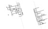
 Reconstructed plan of fort I
The main axes of the town continued the orientation of the fort and vicus.
Indeed, the fort defences and ditches remained in existence with only the gates
removed and the forum (1.1ha) developed on the crossing of the fort’s main streets.
The 2.7km long city defences were built around 200. For the most part, they
consisted of a stone wall, fronted by a ditch, but the northern section was
built as an earth rampart. The defences enclosed c. 40ha of a built up area
which totalled c. 44ha.
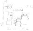
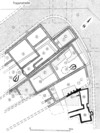
 Plan of the Roman settlement
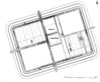
The outside of the (130 x 84m) forum was surrounded by a portico on three sides.
The colonnaded courtyard had a three aisled basilica attached on the east side,
to which further rooms were attached at the rear (73 x 29m). Clues such as an
absence of wall plaster suggest that the building (which was begun in the early
2nd century) was never finished. The basilica was the largest Roman structure
on the right bank of the Rhine and its dimensions are hardly smaller than those
of the Augst basilica.Despite a lack of surviving foundations, an honorific arch has been postulated
on the site of the former fort gate, north of the forum, because of the alignment
of the roads.
 |
 |
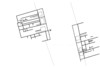
Plan of the forum |
Forum reconstruction |
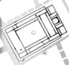
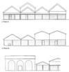
In the south of the settlement, a (c.100 x 90m) complex has been located, with a large internal courtyard and adjoining rooms. It has been identified as a second forum, built in the second half of the 2nd century and an alternative interpretation as an inn (mansio) is less likely.
Immediately to the west was a structure with large hypocausted rooms, and a
bath block which adjoined it immediately to the north, was decorated with high
quality wall paintings. The entire complex has been interpreted as a ‘palace’
for high ranking Roman officials, such as the governor. This interpretation
remains contended, however, but there may have been public baths to the north.
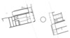
 Plan of the “palace”
In the south-western part of the town, next to the defences, several long-rectangular buildings have been excavated, which might have been warehouses.
The only known sanctuaries are two mithraea, one a sunken building with stairs leading into it (Mithraeum I) and the other a cellar with anteroom and stairs (Mithraeum II). They have been identified on the basis of a cult image and an altar found inside them. Other dedications suggest the presence of a so far unexcavated temple district.
Several fragments of inscribed stone seating are known from a theatre, and sparse surviving features would locate the structure south-east of the city wall.
In the vicinity of the Kellereiplatz, along the northern main road, houses have been excavated that flanked a square-like widening of the road. The occupation consisted of strip buildings, built as post structures from 75AD, and replaced by cill-beam constructions from the early 2nd century. From the second half of the 2nd century these were in turn replaced in stone, but the plots remained stable over the entire life of the settlement, apart from some which were joining together make room for larger buildings. The plots averaged 8-10m wide and the individual houses were originally c.30m long although, in the latest phase, some grew to over 50m in length. The road was lined by a continuous portico and the back yards contained wells and latrines. The residents were traders and craftsmen and a small circular structure in the middle of the road probably served some function during periodic markets.
 |
 |
 |
 |
Roman houses at the Kellereiplatz. Late 1st century
AD |
Roman houses at the Kellereiplatz. Mid 2nd century |
Roman houses at the Kellereiplatz. 3rd century |
Reconstructed frontages of the Roman houses on the
western side of the Kellereiplatzes in the late 1st (top), mid 2nd (middle)
and 3rd century (bottom) |
Smaller parts of residential quarters are known from other parts of the town.
They usually display plot widths of 6-9m and road-flanking porticoes, some of
which were carried on stone columns. During the military occupation, pottery
kilns were located in the south of the vicus, but from the early 2nd century
onwards they were found outside the centre of the settlement, as were the brickworks.
 Roman houses at the Traianstraße
No aqueduct supplying Ladenburg is known. The houses generally had wells in the rear of the plots.
Visible remains
The foundations of the forum basilica can be visited at the church of St.Gallus.
The church is built over the basilica, with its length equalling the width of
the Roman building.
Museum
Finds from Ladenburg can be seen in the Lobdengaumuseum in Ladenburg and in
the Archäologisches Landesmuseum in Konstanz.
Text: Thomas Schmidts
D. Baatz, Lopodunum-Ladenburg a. N. Die Grabungen im Frühjahr 1960. Badische Fundberichte Sonderheft 1 (Freiburg 1962).
M. N. Filgis, Stadt oder Dorf? Zwei römische Siedlungen im Neckarraum. In: Stadt und Umland. Neue Ergebnisse der archäologischen Bau- und Siedlungsforschung. (Mainz 1999) 50-62.
H. Kaiser/C. S. Sommer, Lopodunum. I. Die römischen Befunde der Ausgrabungen an der Kellerei in Ladenburg 1981-1985 und 1990. Forschungen und Berichte zur Vor- und Frühgeschichte in Baden-Württemberg 50 (Stuttgart 1994).
G. Lenz-Bernhard, Lopodunum III. Die neckarswebische Siedlung und Villa rustica im Gewann "Ziegel- scheuer". Eine Untersuchung zur Besiedlungsgeschichte der Oberrheingermanen. Forschungen und Berichte zur Vor- und Frühgeschichte in Baden-Württemberg 77 (Stuttgart 2002).
G. Lenz-Bernhard, Die Neckarsueben in der Gemarkung Ladenburg. In: Ladenburg. Aus 1900 Jahren Stadtgeschichte. (Ubstadt-Weiher 1998) 43-201.
B. Rabold/ C. S. Sommer Lopodunum 98. Vom Kastell zur Stadt (Ladenburg 1998).
O. Schlegel, Germanen im Quadrat. Die Neckarsueben im Gebiet von Mannheim, Ladenburg und Heidelberg während der frühen römischen Kaiserzeit. Internationale Archäologie 34 (Rhaden/Westfalen 2000).
C. S. Sommer, Vom Kastell zur Stadt, Aspekte des Übergangs in LOPODUNVM/Ladenburg und ARAE FLAVIAE/Rottweil. In: Roman frontier studies 1995. Proceedings of the XVIth Congress of Roman Frontier Studies. Oxbow Monograph 91 (Oxford 1997) 511-516.
C. S. Sommer, Vom Kastell zur Stadt. LOPODVNVM und die CIVITAS VLPIA SVEBORVM NICRENSIVM. In: Ladenburg. Aus 1900 Jahren Stadtgeschichte. (Ubstadt-Weiher 1998) 81-201.
Updates on current excavations in Ladenburg can be found in:
Archäologische Ausgrabungen in Baden-Württemberg 1981 ff.